
| | | | | | | |
| | | | | | |
| THUNG KAEO (ทุ่งแก้ว) |
| Text by Tricky Vandenberg - September 2011 |
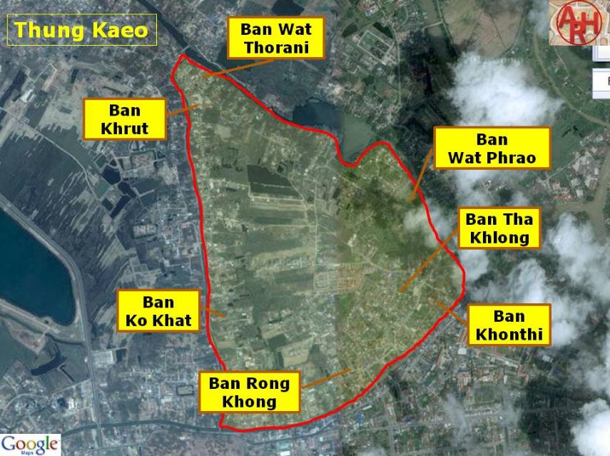

| Thung Kaeo or "Field of Crystal" (1) was an area north of the city of Ayutthaya bordered on the west and north by Khlong Sra Bua; on the east by Khlong Hua Ro and in the south by Khlong Mueang. The area was cut through by at least two canals running parallel with Khlong Sra Bua, being the Pha Lai Canal and the Ban Pla Mo Canal. There existed also a side canal from the Lopburi River opposite Wat Sam Wihan, called Khlong Wat Phrao. The whole area is low land and prone to yearly flooding. Following were the temples in alphabetical order, located in this area: Wat Chao Ya (ruin), Wat Inthawat, Wat Khae (ruin), Wat Khrutharam, Wat Khwit (ruin), Wat Klang, Wat Kuti Thong, Wat Laiso (ruin), Wat Lamut (vanished), Wat Mae Nang Plum, Wat Mai (1) (ruin), Wat Mongkut (ruin), Wat Ngio (vanished), Wat Nom Duan (vanished), Wat Pa Daeng (ruin), Wat Pa Khonthi (vanished), Wat Phisua (mound), Wat Pho (ruin), Wat Phrao (vanished), Wat Raeng (mound), Wat Rang (5) (vanished), Wat Saliang (ruin), Wat Tamnak (2) (mound), Wat Tha Klong (vanished), Wat Wihan Thong (ruin) and Wat Wong Khong. Villages mentioned in the "Geographical description of Ayutthaya: Documents from the palace" [1]: Ban Ko Khat (บ้านเกาะขาด) or Village of the Separated Island - The location is at present not exactly known, but was likely a village on the islet formed by Khlong Sra Bua and Khlong Pha Lai. The community here casted footed cups with a tapering lid for storing medicine, brass bottle gourds for lime, footed trails, wooden scoops for lime and "Lon Hong" for sale. Ban Wat Khrut (บ้านวัดครุธ) - located in the vicinity of Wat Khrutharam. The village molded bulky pots to store water for sale. Fine Arts Department excavations in the period 2000 - 2002 identified that the eastern area near Wat Khrutharam was the production area of large earthen pots, jars or massive storage vessels. The area was a "lerng" manufactory. "Lerng" were large hand mould vessels with a round bottom and paddle stamped all over the body, used for storing liquids or dry articles. [2] Ban Wat Thorani (บ้านวัดธรณี) - The location is at present not exactly known, but was likely a village south east of Wat Khrutharam in the vicinity of Wat Ngio. The community sold sawn timbers of the cotton and bridal couch trees. Ban Wat Phrao (บ้านวัดพร้าว) - located in the vicinity of Wat Phrao. Brahman Indians and Thais fabricated and sold scented powder and oil, scented water, incense sticks and perfumery in the village. Ban Tha Khlong (บ้านท่าโขลง) - located in the vicinity of Wat Tha Klong. The community set up furnaces to forge iron large and small nails and cramp-irons for sale. Ban Khonthi (บ้านคนที) - located in the vicinity of Wat Pa Khonthi. Locals molded earthen spittoons, earthen pots to grow plants, candle pottery, stoves and sculptured elephant figures, horse figures and different types of dolls. Ban Wat Rong Khong (บ้านโรงฆ้อง) - located in the vicinity of Wat Wong Khong. The community here consisted of female vendors who purchased unripe bananas to ripe and boil for sale. Other villages: In the Royal Chronicles of Ayutthaya we find a Ban Pla Mo (Tilapia Village) which should have been located in the vicinity of Wat Raeng. [3] In Phraya Boran Rachathanin's writings we find also an indication of the existence of a Ban Yuan Thale (Village of the Sea Vietnamese), which should be also have been situated in the vicinity of Wat Phrao. (2) [4] On a military map drafted in the 20th century we find the indication of two villages in this area: Ban Hua Ro and Ban Kuti Daeng. Footnotes: (1) The word crystal (Kaeo) is applied to anything gemlike, or beautiful, or royal. (2) ตลาควัดมะพร้าวริมบ้านญวนทะเล. References: [1] พรรณนาภูมิสถาน พระนครศรีอยุธยา เอกสารจากหอหลวง (ฉบับความสมบูรฌ์) - Geographical description of Ayutthaya: Documents from the palace - Dr Vinai Pongsripian - Bangkok (2007) - page 86/87. [2] Development of ceramics production in Ayutthaya - Pakpadee Yukongdi (2009) - Silpakorn University - page 40. [3] The Royal Chronicles of Ayutthaya - Richard D. Cushman (2006) - page 25 / Source: Phan Canthanumat, British Museum, Reverend Phonnarat, Phra Cakkraphatdiphong & Royal Autograph - Nobles Plot to End Usurpation. [4] อธิบายแผนที่พระนครศรีอยุธยากับคำวินิจฉัยของพระยาโบราฌราชาธานินท์ ฉบับชำระครั้งที่๒และภูมิสถนกรุงศรีอยุธยา (2007) - Explanation of the map of the Capital of Ayutthaya with a ruling of Phraya Boran Rachathanin - Revised 2nd edition and Geography of the Ayutthaya Kingdom - Ton Chabab print office - Nonthaburi (2007) - page 97. |