
| | | | | | | |
| KHLONG THA PHRA (คลองท่าพระ) |
| Text & maps by Tricky Vandenberg - April 2013 Updated April 2020 |
| | | | | | |
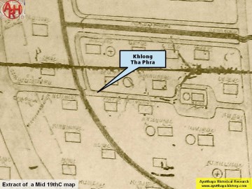
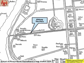
| Khlong Tha Phra (1) also known under the name Khlong Klaep (2) is a defunct canal situated on Ayutthaya's city island of which some stretches still can be seen today on the western side. The canal has its mouth at the former Lopburi River, today the Chao Phraya River. Here stood one of the eleven water gates around the island called Pratu Khlong Klaep. The canal continued under the same name in western direction on the opposite side of the main river by-passing Tamnak Phra Jao Prasat Thong in direction of Wat Suren. The canal ended at the junction with Khlong Chakrai Yai. (3) Beyond this junction, it continued in an eastern direction as Khlong Pa Mo. (3) Sumet Jumsai wrote that on Kaempfer's published map, the Pratu Tha Phra Canal ends in the east by joining Pratu Thep Mi Canal with a zig-zagging canal before reaching the gate of Pratu Thep Mi and added that other evidence seems to suggest that in fact, this canal continues eastwards in a straight line to join the Nai Kai Canal. He wrote that from the “Plan d’Ajuthia”, Bulletin de la Commission Archéologique de l’Indochine année 1912, Paris 1912 (fig. 18). - the extension of Pratu Tha Phra Canal to the Nai Kai Canal is clearly discernable and together with other plans and the aerial photograph, Tha Phra Canal can now be traced from its western gate right across almost the entire length of the city to the east, with a total length of 3.5 km. [1] Trying to situate the temples along the Tha Phra Canal we are in for a difficult exercise with many players. Following the oldest map (mid 19th C), the temples (from east to west) on the northern bank were Wat Salak (aka Wat Kuti Salak), Wat Lanthom Noi, Wat Jom Thong, and Wat Chang; on the southern bank were Wat Pi Rai, Wat Lanthom Yai, Wat Cho and Wat Phra Ngam. In the middle of the canal, but in fact not much likely, stood Wat Jan. The second oldest map (begin 20th C) from Phraya Boran Rachathanin gives another view. On the northern bank were Wat Pi Rai (instead of Wat Salak) and Wat Pa Sathon (instead of Wat Chang). Wat Lanthom Noi and Wat Jom Thong are not indicated. On the southern bank were Wat Pa Phat (instead of Wat Pi Rai), Wat Chon (instead of Wat Lanthom Yai), Wat Cho and Wat Phra Ngam. A map of the Fine Arts Department of 2007 indicates the excavations performed in the area and shows us on the northern bank: Wat Chang, Wat Satdichon, Wat Pa Sai and Wat Pi Rai; on the southern bank only traces of Wat Pa Sathon, Wat Cho and Wat Chon were found. I think it is unjust to conclude that there were only monasteries situated at the origin and near the mouth of Khlong Tha Phra and nothing in between them. There should have been more monasteries along this canal as indicated by the mid-19th century map. The cluster of temples formed by Wat Pa Sai, Wat Satdichon and Wat Chang belongs likely to one single temple and from here onwards I call this cluster Wat Chang. Wat Salak or Wat Kuti Salak on the north bank is mentioned in the old documents. I presume Wat Pi Rai (Yi Rai) must be another name for the same temple. Wat Jom Thong and Wat Lanthom Noi on the north bank were likely never excavated. I retain also Wat Pa Phat on the southern bank, as Pa Phat (Fan Quarter) is mentioned in the same old documents. Wat Chon could be the same temple as Wat Lanthom Yai on the mid-19th C map. In my conclusion we had following temples on the north bank (E to W): Wat Salak, Wat Lanthom Noi, Wat Jom Thong, and Wat Chang; on the opposite side were Wat Pa Phat, Wat Chon, and Wat Cho. Khlong Tha Phra fed probably a marsh on its northern side. The mid-19th century map indicates Wat Jan mid-canal, while Phraya Boran Rachathanin put a monastery called Wat Wihan Klaep higher up in the marsh. South of the mouth of Khlong Klaep was the Phra Racha Wang Lang Landing which had a ferry connecting across the main river with the Wat Lot Chong Landing. (4) [2] Footnotes: (1) ท่า: landing พระ: noble - Canal of the Landing of the Nobles. (2) แกลบ: chaff / paddy husk- Paddy Husk Canal. (3) Sujit Wongthet cuts the canal down east of Wat Chon, naming the stretch towards Wat Pa Phat as Khlong Pa Phat. (4) See "The Boat & Ferry Landings of Ayutthaya". References: [1] Jumsai, Sumet - The reconstruction of the city plan of Ayutthaya (1970) - The Siam Society, Bangkok - page 308 and - page 310 fn 4. [2] Explanation of the map of the Capital of Ayutthaya with a ruling of Phraya Boran Rachathanin - Revised 2nd edition and Geography of the Ayutthaya Kingdom - Ton Chabab print office - Nonthaburi (2007) - page 91-92. |
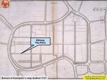
| (Khlong Tha Phra on Kaempfer's published map) |
| (Khlong Tha Phra on a Mid 19th C map) |
| (Khlong Tha Phra on Phraya Boran Rachathanin's map - 1926) |
