| WAT SANGKHA PAT (วัดสังขปัด) |
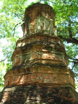
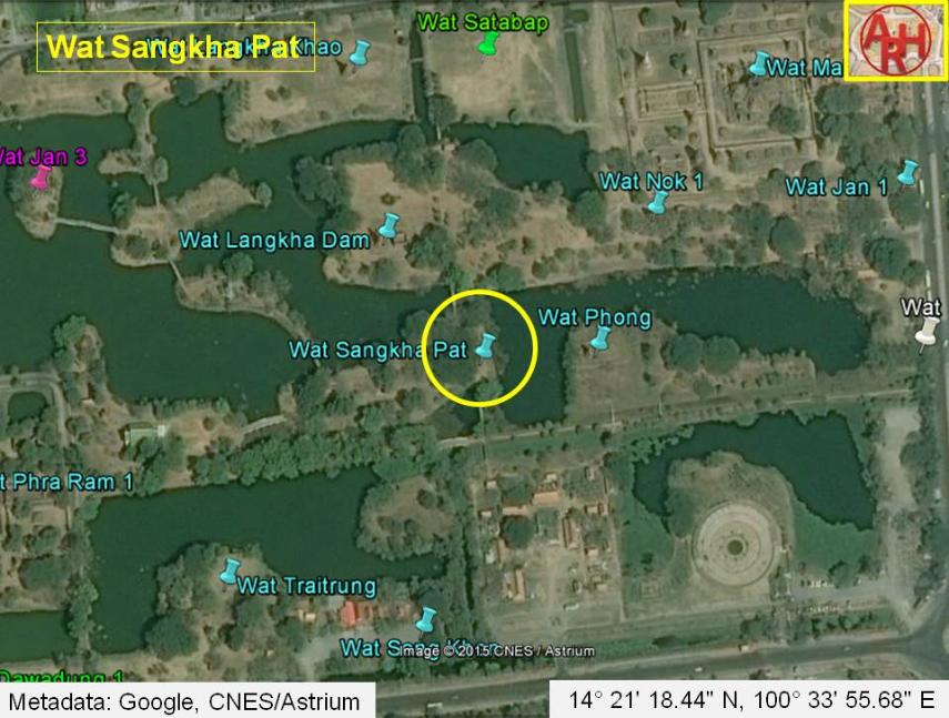
| This deserted temple is located on the city island within the Ayutthaya Historic Park. It can be easily visited on foot or by bicycle. Motor vehicles are not allowed to access it. It is surrounded by trees, which makes it a nice shady spot to relax. There is only one structure in situ at Wat Sangkha Pat. This is a chedi that has been constructed in a style associated with the Haripunchai or Lanna kingdoms. Its architecture includes an octagonal base and multiple layers that get smaller as they taper upward. A number of arched niches showcase standing Buddha images at the upper level. Some of the images are well-preserved, although the heads are missing. Several of the niches also show stucco covered columns. There is an arched entrance on the eastern side. It is hollow, dark, and deep on the inside of the chedi. South of the chedi, there is a cement block that serves as a platform for the lower portion of a free-standing Buddha image. There is little known about the history of Wat Sangkha Pat. Its architectural style suggests that it was used by people from the northern kingdoms. This monastery was situated along a road beside Khlong Nam Cheawn - a canal that brought fast moving water from Khlong Mueang (the old Lopburi River) to Bueng Phra Ram. The water flow of this canal was regulated by a gate known as Pratu Tasibiay. A portion of the gate's wall can still be seen along U-Thong Road. This canal was aligned with a number of temples: Wat Chum Saeng, Wat Langkha Khao, Wat Langkha Dam, Wat Yan Sen, and Wat Phong. |

| | | | | | | | |
| Text & photographs by Ken May - August 2009 |


| | | | | | | |
| Addendum The water flow of Khlong Nam Chiao was not regulated by the gate known as Pratu Tha Sip Bia (the Gate of the Landing of the Ten Cowries). This gate was a large land gate in the northern city wall situated near the northeastern corner of the outer wall of Wat Thammikarat. Following Phraya Boran Rachathanin (PBR) the Nam Chiao canal entered the city two entries further to the east at an entrance called Chong Maha Thera Mai Sae. The canal aligned with Wat Chum Saeng, Wat Langkha Khao, Wat Langkha Dam, Wat Sangkha Pat, and Wat Phong mentioned above, was called Lam Khu Pak Sra. [1] This author believes that the local people could have called the latter Khlong Nam Chiao, but this is in contradiction with PBR writings. References: [1] Athibai Phaenthi Phra Nakhon Sri Ayutthaya kap khamwinitjai khong Phraya Boran Racha Thanin - Explanation of the map of the Capital of Ayutthaya with a ruling of Phraya Boran Rachathanin - Revised 2nd edition and Geography of the Ayutthaya Kingdom - Ton Chabab print office - Nonthaburi (2007) - page 53. |
| Addendum & maps by Tricky Vandenberg - May 2011 Updated May 2015 |
| (View of the chedi of Wat Sangkha Pat) |
| (View of the chedi of Wat Sangkha Pat) |
| (View of the chedi of Wat Sangkha Pat) |
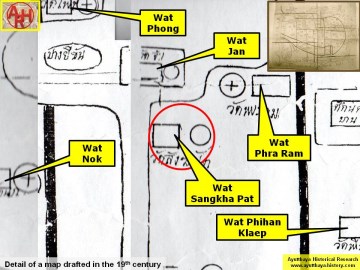

| (Detail of a 19th century map - Courtesy of the Sam Chao Phraya Museum - map is orientated S-N) |
| (Detail of Phraya Boran Rachathanin's map - Anno 1926) |
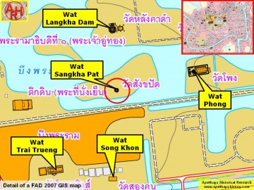
| (Detail of a 2007 Fine Arts Department GIS map - Courtesy of the Fine Arts Department - 3th Region) |