| WAT SING 1 (วัดสิงห์) |
| Wat Sing or the Monastery of the Lion was located on the city island in the western area of Ayutthaya in Pratu Chai Sub-district. The temple was situated south of a former canal called Khlong Fang near its water gate, which made a junction with the Chao Phraya River (the former Lopburi River), and the Sat Kop Fortress. Wat Khok lied north of the temple, while Wat Sop Sawan and Wat Khok Chang stood on its south. There are no traces anymore of the former monastery. A Thai Army camp has been constructed on the site. The temple is classified as disappeared. Historical data about the monastery and its construction are unknown. The site is indicated on a mid-19th century map in an identical position as on Phraya Boran Rachathanin's map drafted in 1926. The mid-19th century map indicates the existence of a chedi, which at present has disappeared as the ancient monastic complex was leveled to become an army camp. In the Late Ayutthaya period there was a fresh market in front of the monastery called Lion's Head Market. [1] Wat Sing was located in geographical coordinates: 14° 21' 18.44" N, 100° 32' 54.89" E. References: [1] Markets and Production in the City of Ayutthaya before 1767: Translation and Analysis of Part of the Description of Ayutthaya - Chris Baker - Journal of the Siam Society, Vol. 99, 2011 - page 65. |

| | | | | | | | |
| Text & maps by Tricky Vandenberg - October 2009 Updated April 2011, March 2013, June 2015 |
| | | | | | | |

| (Detail of Phraya Boran Rachathanin's map - Anno 1926) |

| (Detail of a 19th century map - map is orientated S-N) |
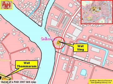
| (Detail of a 2007 Fine Arts Department GIS map - Courtesy of the Fine Arts Department - 3th Region) |
