| WAT WONG KHONG (วัดวงษ์ฆ้อง) |
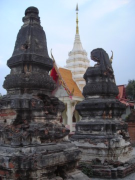
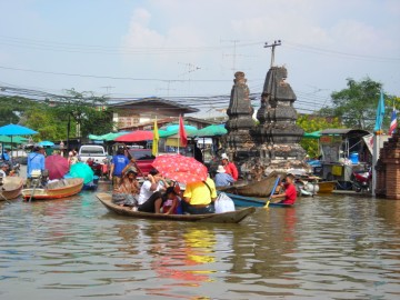
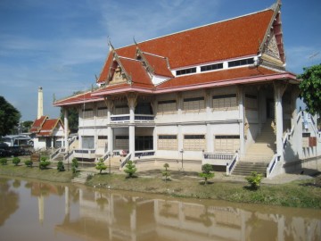
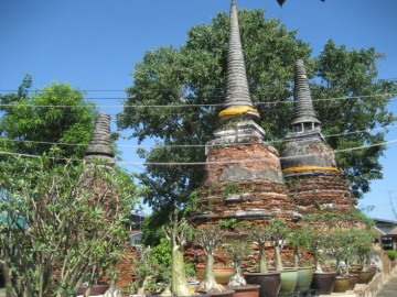
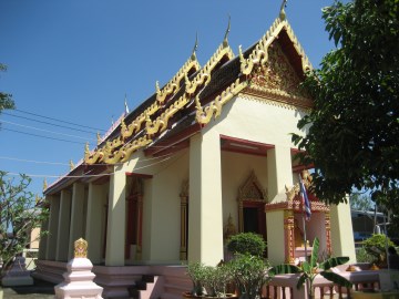
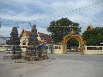
| Wat Wong Khong is located off the main island - in the northern part of the city. This active monastery can easily be reached by motor vehicle by crossing the bridge on Chikun Road or by boat from Khlong Mueang (the old Lopburi River). The monastery’s location by the river is vulnerable to flooding, so many of the older structures have suffered damage. Wat Wong Khong is a single monastery, but a modern road cuts through the center of it. On the side of the canal, there are several sermon halls and some kuti where monks live. These have been built in the modern Rattanakosin style. A large Chinese shrine was built a few years ago featuring a god with multiple arms. There are two chedi beside the road. Both are decorated with the lotus design and have several redented corners. This style is suggestive of the Late Ayutthaya period. Both chedi are full of holes from looting and covered with soot from car exhaust. The opposite side of the road contains the more active preaching hall. Three large bell- shaped chedi are located in a courtyard on the west side of this building. This area has been renovated with floor tiles and an improved foundation layer. A few smaller chedi are also located in the same area. The style of chedi suggests that this temple is connected to the Middle Ayutthaya period, and Royal Chronicles support this idea. Wat Wong Khong is mentioned in relation to a war with Lawaek (Cambodia) in 1570. During the reign of King Maha Thammaracha, the Khmer king advanced with his armies to the Siamese capital and set up an elephant stockade at Wat Sam Wihan. The enemy troops were posted at intervals from there to Wat Rong Khong Monastery and Kuti Thong monastery. Thirty elephants were also halted at Wat Phra Meru with 4-5 thousand men (Cushman 77). Ayutthaya troops, however, were able to kill the Lawaek commander, Phra Campathirat, by firing cannons directly at enemy troops barricaded at Wat Sam Wihan. Phra Campathirat died while still perched on the neck of his elephant, and Lawaek troops then retreated from the capital. In the Ayutthaya period, Wat Wong Khong was an important ferry crossing point that connected to Wat Tha Sai on the other side (Kasetsiri & Hedges 329). This monastery was set in a prime location because it provided vital access to Khlong Pratu Khao Pluak (approximately where Chikun Road is today). |

| | | | | | | | |
| Text & photographs by Ken May - August 2009 |
| | | | | | | |
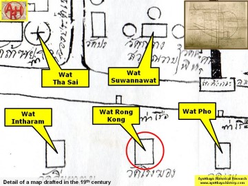
| Addendum The temple was before known as Wat Rong Khong. The renaming of "Rong" by "Wong" seems to come from the following: "rong" which means building, sounds also as coffin (Th: long). The word "rong" was not felt as a very auspicious name for a temple, hence the name change. The same occurred to Wat Pradu Songtham, being before two temple sites Wat Pradu and Wat Rongtham. Here also Rongtham was changed into Songtham. In the manuscript "Testimony of the king from Wat Pradu Songtham", a document likely compiled in the Early Ratanakosin Period, is written that there was a land market at Wat Rong Khong. [1][2][3] There was also a boat ferry between Wat Tha Sai (Sand Landing) to Wat Rong Khong. In the Ayutthayan era there were twenty-two ferry routes between the main land and the city island. The northern side had seven ferries. The six other crossings were: Tha Nuea to Wat Khun Yuan, Tha Khan to Sala Trawen, Tha Sip Bia to Wat Pho, Wat Song to Wat Pa Khonthi and Tha Khun Nang to Wat Mae Nang Plum. [1] See "The Boat & Ferry Landings of Ayutthaya". There was a village beside Wat Rong Khong along the road in front of Chaophraya Jakri’ s house. In the village women traders bought raw bananas to ripen and boil for sale. [1] [3] Wat Rong Khong is mentioned in the Royal Chronicles of Ayutthaya as the location were Cambodian troops were positioned in an attack on Ayutthaya in 1570. "Meanwhile, the King of Lawæk advanced with his army to the Capital and Royal Metropolis of Ayutthaya and encamped his army in the vicinity of Kathum Village. At that moment the King ordered Müang Nakhòn Phrom and the three thousand troops [CDEF: of the men] of Hongsawadi to man the positions on the front wall, and all the high-ranking officials of the provincial cities to examine and post soldiers to the positions on the walls and at intervals around the Royal Metropolis. The King of Lawæk advanced with his army and halted his elephant in Sam Phihan Monastery. And the enemy troops were posted at intervals to Rong Khòng Monastery and Kuti Thòng Monastery. Then they brought about thirty elephants and halted them in Na Phra Meru Rachikaram Monastery with about four thousand men. The King of Lawæk had soldiers board five boats and cross the river to attack Prince Sanuk’s corner of the wall. The King proceeded there and, halting his palanquin, sent his soldiers up to fight. The enemy being vanquished, the King then ordered a carong cannon fired on the enemy elephants which were standing in Sam Phihan Monastery. Phra Campathirat, who was the [commander of the] vanguard of the King of Lawæk, was hit and killed on the neck of his elephant. The King of Lawæk withdrew and returned to his army at Kathum Village. Three times they advanced to attack in that way but were unsuccessful. So the King of Lawæk, ending the campaign and returning, swept up the families in the vicinity of the villages in the paddy fields and in Nakhòn Nayok and took them to Lawæk. At that time the King of Lawæk repeatedly organized troops to scout about, both by land and by boat, and the inhabitants of Canthabun, the inhabitants of Rayòng, the inhabitants of Chachoengsao and farmers were speedily lost to the Lawæk enemy in great numbers." [5] Wat Wong Khong is situated in geographical coordinates: +14° 21' 51.23" N, +100° 33' 59.60" E. References: [1] Phanna phumisathan phranakhon si ayutthaya: ekkasan jak ho luang [Geographical description of Ayutthaya: Documents from the palace]. Edited by Winai Pongsripian. Bangkok: Usakane, n. d. [2007]. [2] Note on the Testimonies and the Description of Ayutthaya - Chris Baker - Journal of the Siam Society, Vol. 99, 2011 - page 77 (paragraph on KWPS). [3] Markets and Production in the City of Ayutthaya before 1767: Translation and Analysis of Part of the Description of Ayutthaya - Chris Baker - Journal of the Siam Society, Vol. 99, 2011- page 52/54. [4] Athibai phaen thi phra nakhon si ayutthaya - Explanation of the map of the Capital of Ayutthaya with a ruling of Phraya Boran Rachathanin - Revised 2nd edition and Geography of the Ayutthaya Kingdom - Ton Chabab print office - Nonthaburi (2007) - page 92. [5] The Royal Chronicles of Ayutthaya - Richard D. Cushman (2006) - page 77 / Source: British Museum, Reverend Phonnarat, Phra Cakkraphatdiphong & Royal Autograph - War with Lawæk, 1570. |
| Addendum, maps & photographs by Tricky Vandenberg Updated March 2016 |
| (Chedi rai at Wat Wong Khong) |
| (Chedi rai on premises) |
| (Flooding at the temple site) |
| (Resting pavilion on the old Lopburi River) |
| (View from the south) |
| (Ordination hall of Wat Wong Khong) |

| (Detail of a 19th century map - Courtesy of the Sam Chao Phraya Museum - map is orientated S-N) |
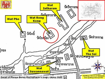
| (Detail of Phraya Boran Rachathanin's map - Anno 1926) |
| (Detail of a 2007 Fine Arts Department GIS map - Courtesy of the Fine Arts Department - 3th Region) |
