
| | | | | | | |
| KHLONG TAKHIAN |
| | | | | | |
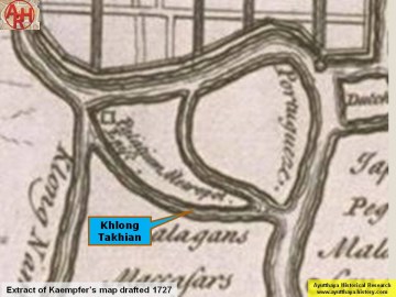
| Khlong Takhian (1) is a still existent canal situated south of Ayutthaya's city island, running mainly through Pak Kran and Khlong Takhian sub-districts. The canal is named after the Malabar Ironwood, a tree often used for making boats and ship masts. The canal has its origin at the Chao Phraya River (2) near the St Joseph Church in the former Cochin Chinese settlement and has its mouth further south, back in the Chao Phraya River, below the former Portuguese settlement and opposite the northern tip of Rian Island (Ko Rian). The southern area of Ayutthaya is shaped by Khlong Takhian and the Chao Phraya River; and separated into two areas by Khlong Khu Cham. The eastern area was populated by the Chinese (around Bang Kaja) and Portuguese trading communities along the west bank of the Chao Phraya River. The western area was inhabited by Cochin Chinese refugees - mostly Christians, while the Malay occupied the southern area. Cham Muslims from Cambodia and Vietnam settled in between these areas along Khlong Khu Cham. The canal was a man-made shortcut or "khlong lat" between two stretches of the Chao Phraya River, used by boats to avoid the heavy current of the river and the turbulent waters near the Bang Kaja confluence. Opposite the entry of the Takhian canal on Ayutthaya's city island, stood Pom Wang Chai, a small fortress as part of the city defense wall, strategically located in front of the confluence. The canal was named by the French "Canal du Grand Cochon" (3), which was translated by Andrews as the "Great Cochon River" (4). On most of the older Thai maps we will read Khu Lakhon Chai. Kaempfer indicates on his map another canal named Nam Ja, running south and having the same origin as Khlong Takhian. Documents indicate that in the Ayutthayan era, the marine vessel dockyard was located near the mouth of Khlong Takhian. [1] The dock housed around 30 large marine warships and 100 more smaller war vessels, all made from Ironwood. The boats were kept in a roofed boat house with walls containing a row of dry docks along the main river. The boats were stored with the bow in direction of the main land and the stern towards the river. The Thai historian Sujit Wongthet indicates this dockyard opposite Wat Wang Chai at the former Cochin-Chinese (French) settlement, in fact at the origin of the canal. In my opinion the marine boathouse should have been situated at the mouth, opposite Rian Island for tactical as well strategic reasons. The map of François Valentijn (1724) mentions "'S Konings werf" or the King's shipyard on the main river and south of the mouth of Khlong Takhian, opposite Ko Rian. This shipyard was the marine boat house. The latter resorted under the Phraya Racha Wangsan, the division chief (Chao Krom Asa Cham), in charge of the Cham volunteers consisting of Muslims of Cham and Malay descent. [2] Near the origin of Khlong Takhian was a Chinese Village (5) with many shops in brick buildings selling more Chinese than Thai goods. Behind the large Khu Lakhon Chai market was a Chinese Shrine and also four entertainment halls were women presented acts (Lakhon - theater), including the world's oldest profession. (6) [3] The area was linked to the city island by a ferry route between the landing of Wat Wang Chai on the city's side across to the landing near Wat Nak at the beginning of Khlong Takhian. The Takhian Canal is mentioned in the Royal Chronicles of Ayutthaya. [4] Along the left bank of Khlong Takhian from north to south were following sites: Wat Si Pho, Wat Mai, Wat Samphao Lom, Wat Khok Jindaram and the Kudi Cho Fa Mosque. On the right bank were the old Wat Klang, the new Wat Klang (Khlong Takhian) and Wat Nak. We find also a number of new mosques being the Amadiya Mosque, Sunnia Mosque, Hidayatun Islam Mosque , Yama Lun Islam Mosque on the left bank; the To Ifa Mosque and the Yami Ul Islam Mosque on the right bank. Mae Takhian The Takhian tree is known in Thailand to house a female spirit, known as Nang Thakian or Lady Takhian. In the imagination of the people, Lady Takhian usually takes the form of a beautiful maiden who sometimes makes a wailing and piercing sound when the tree, her abode, is felled. Unforeseen and mysterious calamities will befall the person or persons who destroy her abode. A Takhian tree growing near the bank of a river with its roots protruding above ground is to be avoided, for the spirit of that tree is fierce. Whoever relieves him/herself near the base of her tree will suffer from ulcers. To add to the belief, Takhian trees are usually found in a monasteries where all sorts of ghost stories emanate. [5] The origin of the Mae Takhian tale is likely evolving from the massive logging in earlier times of the Takhian tree to build barges. As written above, this kind of tree is only found in monasteries today. Outside the monasteries most of the Ironwood had been logged for business purposes. The ghost story was likely created in order to protect this species of tree from cutting. A modern version since the 1980's to protect trees from being cut down is their ordination, involving the ritual of tying the sacred yellow cloth around the tree. Footnotes: (1) Latin Name: Hopea Odorata - Sometimes locally called Mai Khaen or Mai Khaen Hua. Trade name: Ceylon/Malabar Ironwood. Malabar Ironwood is reputed for its hardness. It is a strong light and durable timber resistant to termites used for boat building. (2) Only since the mid 19th century when the Chao Phraya River was deviated to Ayutthaya; before the Lopburi River. (3) See Bellin's map - The French had their own pronunciation of "Khu Cham" (Moat of the Cham), calling it "cochon" meaning "pig" or "swine". We can derive from the French that Khlong Takhian was called Khu Cham Yai. What today we call Khlong Khu Cham, must have been the Khu Cham Noi. Curiously enough, Bellin indicates on his map the direction of the current in Khlong Takhian towards the main river. (4) See Andrews' map. (5) Likely Cochin-Chinese as this location was their designated area. (6) Chris Baker suggests that the denomination of the canal as Khun Lakhonchai could have been derived from the entertainment area at the beginning of Khlong Takhian. References: [1] Geographical description of Ayutthaya: Documents from the palace - Dr Vinai Pongsripian - Bangkok (2007). [2] The Shi’ite Muslims in Thailand from Ayutthaya Period to the Present - Julispong Chularatana. [3] Before Ayutthaya Fell: Economic Life in an Industrious Society - Markets and Production in the City of Ayutthaya before 1767: Translation and Analysis of Part of the Description of Ayutthaya - Chris Baker - JSS 99. [4] The Royal Chronicles of Ayutthaya - Richard D. Cushman (2006) - page 46-7 / Source: Phan Canthanumat, British Museum, Reverend Phonnarat, Phra Cakkraphatdiphong & Royal Autograph - The Hongsawadi Army Invests Ayutthaya. [5] Some Siamese Superstitions about trees and plants - Phya Anuman Rajadhon - JSS 049. |
| Text & photographs by Tricky Vandenberg - March 2013 |


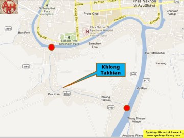


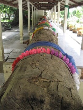

| (Khlong Takhian) |
| (Khlong Takhian on de La Loubere's map -1691) |
| (Khlong Takhian on Kaempfer's map - 1727) |
| (Mae Takhian shrine at Wat Ban Phat) |
| (Mae Takhian shrine) |
| (Ship's mast at Wat Thong Bo) |

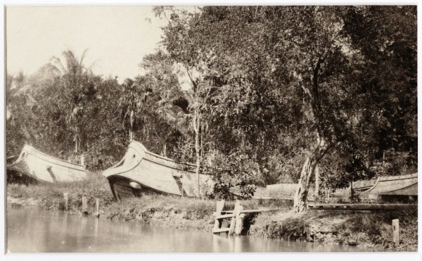
| (War junks in the Ratankosin era at Samsen Creek - Bangkok) |