| | | | | | | |
| MAIN STREET |
| Text & photographs by Tricky Vandenberg - August 2010 |
| | | | | | |
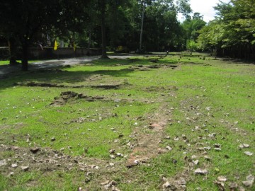
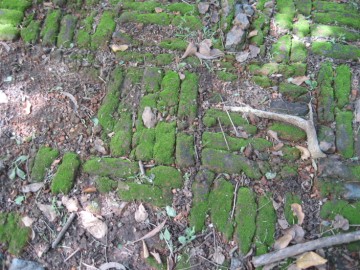
| Ayutthaya's main street started at the northeastern corner of the Grand Palace near Pratu Jakromhima and the crossing with a road leading to the Chang Bridge. The street had a width of 5 wa (10 meters) and was made of brick. The main street went straight from the northeastern corner towards the southeastern corner; turned to the west for a short distance and continued straight south towards Pratu Chai or the "Gate of Victory" situated close to north bank of the main river (present Chao Phraya River). The street passed as thus from north to south, Wat Thammikarat, the royal cremation grounds in front of Viharn Mongkhon Bophit, Wat Phra Ram, the main drum tower, the crossing with Talaeng Kaeng road, the Phra Kan shrine, San Chao Thong, the canal crossing of Khlong Pa Mo, Wat Borom Phuttharam, Wat Prasat to finally end at Pratu Chai. On its southern stretch the street ran parallel with Khlong Chakrai Noi. On the Bellin and Andrews maps the street is called respectively "Rue du Barcalon" and "Barcatan Street" (the latter is a faulty take-over of Bellin's map). Barcalon is the Portuguese corruption of "Phra Khlang", the Minister of External Relations and Maritime Trading Affairs of Ayutthaya. The street was used for purposes such as the royal Kathin processions (1), royal monk hood entries and funeral processions. The street ran approximately where Sri Sanphet road is at present. Near the east wall of the Grand Palace on the present temple grounds of Wat Thammikarat, the brick remnants of this road still can be seen. Footnotes: (1) The "Thot Kathin" annual merit-making ceremony is held at the end of the rainy season. "Thot" means to make an offering to a monk and "Kathin" means an embroidery frame. References: [1] อธิบายแผนที่พระนครศรีอยุธยากับคำวินิจฉัยของพระยาโบราฌราชาธานินท์ ฉบับชำระครั้งที่๒ และ ภูมิสถนกรุงศรีอยุธยา (2007) - page 98/99. |