| WAT CHANG 3 (วัดซั้ง) |

| | | | | | | | |
| Updated April 2011, April 2013, April 2014 |
| | | | | | | |


| (Detail of Phraya Boran Rachathanin's map - Anno 1926) |
| (Detail of a 19th century map - Courtesy Sam Chao Phraya Museum) |
| Wat Chang or the Monastery of the Elephant was situated on the city island in the southwestern area of Ayutthaya at Pratu Chai sub-district. The monastery stood on the north bank of Khlong Tha Phra also called Khlong Klaep. The former temple was situated just north of Wat Cho on the opposite side of the canal. In its immediate vicinity were Wat Satdichon, Wat Pa Sai and Wat Pa Sathon. Wat Satdichon, Wat Chang and Wat Pa Sai were situated closely to each other. A 2007 Fine Arts Department (FAD) map based on conducted excavations shows the location of the three temples, which could lead to the conclusion that the structures were part of one single monastery. On the mid-19th century map we find the indication of Wat Chang in this area. Why Phraya Boran Rachathanin has divided this area (contrary to the mid-19th C map) in a location with three temples in close proximity, is not known. In situ is a ruin covered in vegetation, laying behind a private property. The foundation of a chedi with broken spire still is visible. The site is mentioned on Phraya Boran Rachathanin's map drafted in 1926 in a nearly identical position as on a mid-19th century map. Historical data about the monastery and its construction is unknown. The site is located in Geo Coord: +14° 20' 49.82" N, +100° 32' 44.99" E. It is possible that the temple was linked to the location of the elephant stables belonging to the Rear Palace. For the record, the locals at the time of our visit called this location Wat Cho. |


| (View of the location) |
| (Ruins in situ) |
| (Ruins in situ) |
| (Ruins in situ) |

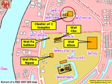
| (Detail of a 2007 Fine Arts Department GIS map - Courtesy of the Fine Arts Department - 3th Region) |

| (Detail of a 1993 Fine Arts Department map - Courtesy Khun Supot Prommanot, Director of the 3th Regional Office of Fine Arts) |