| WAT JAO PHRAM (วัดเจ้าพราหมณ์) |
| Wat Jao Phram or the Monastery of the Brahman is situated in the southwestern area of Ayutthaya's city island in Pratu Chai Sub-district. The monastery is located along Khlong Chakrai Yai, an extension of Khlong Tho. Wat Jao Phram is part of the Somdet Phra Sri Nakharin Park. The monastery, clearly visible from the road longing Khlong Chakrai Yai, is completely surrounded by a moat and as thus difficult to visit. The site is indicated on a mid-19th century map and features a prang and a monastic structure, still existing today. The prang with redented angles was made of brick and decorated with stucco, featuring construction work of the Early Ayutthaya period (1351 - 1488 CE). [1] There is also evidence of earlier restoration of the complex. The base of the prang was covered to be connected with the vihara in the Late Ayutthaya period (1629 - 1767 CE). The temple was seriously dilapidated and restored by the Fine Arts Department last century. [1] Wat Jao Phram, strange enough, does not feature on Phraya Boran Rachathanin's (PBR) map drafted in 1926, which shows an empty space in that area. Historical data about the monastery and its construction are unknown, as there is no evidence from documents . In the vicinity of Wat Jao Phram stood a bridge crossing Khlong Chakrai Yai and called Khun Lok Bridge. [2] Khun Lok could be translated as Ruler of the World, which is in fact Brahma, the Creator. There could be a link between the name of the temple and the bridge as both are referring to Brahma. For this reason, the temple could also have been known as Wat Khun Lok. The site is located in geographical coordinates: 14° 20' 39.92" N, 100° 33' 21.24" E. References: [1] Ayutthaya Historical Park - Fine Arts Department (2003) - page 62. [2] Markets and Production in the City of Ayutthaya before 1767: Translation and Analysis of Part of the Description of Ayutthaya - Chris Baker - Journal of the Siam Society, Vol. 99, 2011 - page 66. |

| | | | | | | | |

| | | | | | | |
| Text & photographs by Tricky Vandenberg - April 2009 Updated April 2014 |
| (View of wat Jao Phram from the east) |
| (View of the south side) |


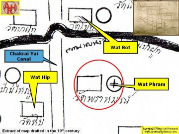
| (Detail of a 19th century map - Courtesy Sam Chao Phraya Museum) |

| (Detail of a 2007 Fine Arts Department GIS map - Courtesy of the Fine Arts Department - 3th Region) |