| WAT CHUM SAENG (วัดชุมแสง) |
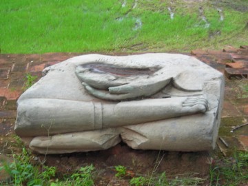
| This partially restored ruin is located on the northern side of Naresuan Road, beside be seen directly across the street from Wat Langkha Khao. Wat Chum Saeng was aligned toward the east/west axis. Its primary feature is a large bell-shaped tower. This has eroded over the years, but its harmika and spire are mostly intact. The spire has at least 17 rings, but the finial has disappeared. A sermon hall and portions of its foundation are still visible east of this chedi. A large Buddha image sits on the altar, but its arms and head remain missing. A tree currently grows at the altar, and a few fragments of Buddha images are scattered nearby. The boundary walls of Wat Chum Saeng are still visible at ground level. There are also traces of a moat. Wat Chum Saeng was situated along Khlong Nam Cheawn – a canal that brought fast moving water from Khlong Mueang (the old Lopburi River) to Bueng Phra Ram. The water flow of this canal was regulated by a gate known as Pratu Tasibiay. A portion of the gate’s wall can still be seen along U-Thong Road. This canal was aligned with a number of temples: Wat Yan Sen, Wat Langkha Khao, Wat Langkha Dam, Wat Sangkha Pat, and Wat Phong. There is not much known about the history of Wat Chum Saeng. The architectural style of its bell-tower chedi suggests that this monastery was built in the Middle Ayutthaya period. Wat Chum Saeng was still covered by a swamp back in 2002, which made it difficult to visit on foot. However, this area has now been drained making it easy to access. There are still people living in dilapidated houses around this territory. Their neighborhood provides a quick shortcut to Wat Yan Sen. |

| | | | | | | | |
| Text & photographs by Ken May - August 2009 |


| | | | | | | |
| Addendum The water flow of Khlong Nam Chiao was not regulated by the gate known as Pratu Tha Sip Bia (the Gate of the Landing of the Ten Cowries). This gate was a large land gate in the northern city wall situated near the northeastern corner of the outer wall of Wat Thammikarat. Following Phraya Boran Rachathanin (PBR) the Nam Chiao canal entered the city two entries further to the east at an entrance called Chong Maha Thera Mai Sae. The canal aligned with Wat Chum Saeng, Wat Langkha Khao, Wat Langkha Dam, Wat Sangkha Pat, and Wat Phong mentioned above, was called Lam Khu Pak Sra. [1] This author believes that the local people could have called the latter Khlong Nam Chiao, but this is in contradiction with PBR writings. The site is located in geographical coordinates: 14° 21 '28.64" N, 100° 33' 52.63" E. References: [1] อธิบายแผนที่พระนครศรีอยุธยากับคำวินิจฉัยของพระยาโบราฌราชาธานินท์ ฉบับชำระครั้งที่๒และภูมิสถนกรุงศรีอยุธยา (2007) - Explanation of the map of the Capital of Ayutthaya with a ruling of Phraya Boran Rachathanin - Revised 2nd edition and Geography of the Ayutthaya Kingdom - Ton Chabab print office - Nonthaburi (2007) - page 53. |
| Addendum & maps by Tricky Vandenberg - May 2011 Updated April 2014 |
| (View from the south) |
| (Remains of a Buddha statue) |
| (View of the chedi in Ayutthaya style) |
| (Remains of a Buddha statue) |


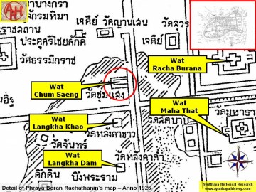
| (Detail of Phraya Boran Rachathanin's map - Anno 1926) |
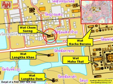
| (Detail of a 2007 Fine Arts Department GIS map - Courtesy of the Fine Arts Department - 3th Region) |
