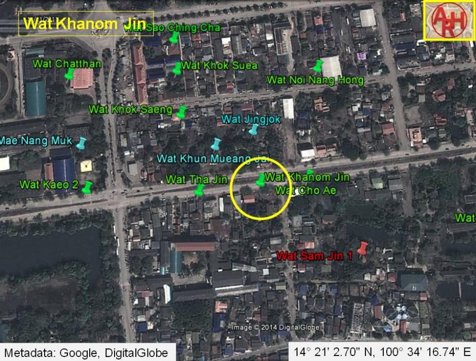
| WAT KHANOM JIN (วัดขนมจีน) |
| Wat Khanom Jin or the Monastery of the Thin Rice Noodles was once connected to a chain of Chinese pagodas north of Khlong Pratu Jin. This canal - now buried - once flowed along an east-west axis toward the Chinese Gate (Pratu Jin), intersecting with Khlong Pratu Khao Pluak (the canal that once flowed from north to south in front of Wat Maha That). The nearest modern landmark is Chiresat Witthayalai School. Wat Khanom Jin appears on Phraya Boran Rachathanin's (1926) map just south of Wat Khun Mueang Chai. It also appears on a Fine Arts Department Map of 1997, but in a slightly different location. Regardless, this temple can be classified as "disappeared" because no trace of it can be found today. It is not clear what this temple looked like, nor do we know if it was just a basic joss house or shrine. No trace of it can be seen for certain. It isn't clear when Wat Khanom Jin was originally founded or when it disappeared. During the Ayutthaya period, a large population of Chinese maritime traders settled in this area, and this temple was situated by a road known as China Street. Its name implies that Chinese restaurants might have been located in the vicinity as well. Engelbert Kaempfer wrote in 1727 that China Street was made of brick and included some of the best houses in the city (p 44). In addition to the Chinese population; French, Dutch, Muslim, and English merchants also resided along this road - including the Greek opportunist, Constantine Phaulkon. China Street is also documented on the French map by Sieur de La Mare (1751). This temple probably "disappeared" as a new population moved into the neighborhood during the Ratanakosin period. Khlong Pratu Chin and Khlong Pratu Khao Pluak were both buried in the rush to modernize the city. Unfortunately, Wat Khanom Jin has not survived into the new era. |

| | | | | | | | |
| | | | | | | |
| Text by Ken May - January 2009 |
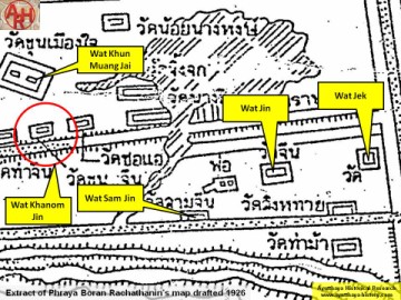
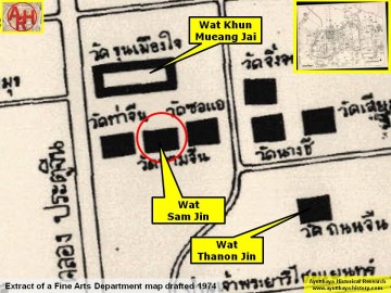
| Addendum Wat Khanom Jin is mentioned - as written above - on Phraya Boran Rachathanin's map drafted in 1926. On a 1974 Fine Arts Department map, the temple (in an identical position) is named Wat Sam Jin or the Monastery of the Three Chinese. The ruin called Wat Sam Jin today is mentioned on the 1974 map as Wat Thanon Jin or the Monastery of the Chinese Street. On all later FAD maps Wat Khanom Jin is not mentioned anymore. The temple was probably situated on what is today the wide avenue called Rojana Rd, leading to the Naresuan and Pridi Phanom Yong Bridges. Wat Khanom Jin was located approximately in Geo Coord: 14° 20' 54.56" N, 100° 35' 29.51" E. |
| Addendum & maps by Tricky Vandenberg - January 2014 |
| (Detail of Phraya Boran Rachathanin's map - Anno 1926) |
| (Detail of a 1974 Fine Arts Department map - Courtesy Dr. Surat Lertlum, Chulachomklao Royal Military Academy) |