| WAT KRABUE 2 (วัดกระบือ) |

| | | | | | | | |
| | | | | | | | |
| Text & map by Tricky Vandenberg - November 2010 |
Wat Krabue or the "Monastery of the Buffalo" is a vanished temple formerly located
on the city island in present Pratu Chai sub-district, in the vicinity of an area formerly
called Laem Sarapha.
Following a map of the 19th century the monastery was situated along the east bank of
Khlong Pratu Jin and north of the road running over the Pratu Talad Jin Bridge. On the
opposite site stood the presently vanished Wat Mai, while on its east side was the also
presently vanished Wat Noi Nang Hong. To the north stood Wat Khun Khon Jai,
presently called Wat Khun Mueang Jai, a still existing restored ruin.
Historical data about the monastery and its construction are unknown. The map indicates
although the existence of a chedi.
The temple is mentioned on Phraya Boran Rachathanin's (PBR) map drafted in 1926, but
in a location which is called Wat Pa Ek on the above mentioned 19th century map. On
PBR's map Wat Krabu could have been one or more structures he indicated as Wat Tha
Jin, Wat Khanom Jin or Wat Cho Ae, south of Wat Khun Mueang Jai on his map.
Making an assessment off all the monastic structures, in the zone demarcated by Chikun
Rd, Pa Thon Rd, Pridi Banomyong Rd and U-thong Rd is rather difficult, as the position
and name of the structures varies on different maps. On a 19th century map there are 15
structures counted, while on the 20th century PBR map there are 13 mentioned. There is
inconsistence in the names and the positions. Even a map drafted in the 90's by the Fine
Arts Department, what I presume, based on excavations in the zone, shed no light on this
matter. Positions of monastic structures can be asserted, but their ancient names will
remain questioned forever.
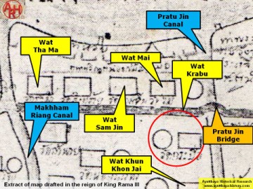
| (Wat Krabu on a mid-19th Century map) |