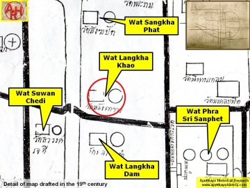
| WAT LANGKHA KHAO (วัดหลังคาขาว) |
| This temple ruin is located in an open field within the Ayutthaya Historical Park. It is easily seen from the southern side of Naresuan Road. There is a single bell-shaped chedi in situ at Wat Langkha Khao. It has been renovated by the Fine Arts Department. The chedi has an octagonal base with several layers leading to its relic chamber. There are approximately 19 rings on its spire. The finial is missing, but the harmika is in good shape with a full covering of stucco. There is entrance on the eastern side of the chedi. The inner chamber is hollow and full of bats. There are no other structures viewable at this site. Wat Langkha Kao was aligned toward the east/west axis. Given the similarity in their names, this monastery probably had some connection with Wat Langkha Dam. There isn’t much historical information available about this temple. The name refers to the white tiles that were once on its roof. Wat Langka Khao was situated along a road beside Khlong Nam Cheawn - a canal that brought fast moving water from Khlong Mueang (the old Lopburi River) to Bueng Phra Ram. The water flow of this canal was regulated by a gate known as Pratu Tasibiay. A portion of the gate’s wall can still be seen along U-Thong Road. This canal was aligned with a number of temples: Wat Chum Saeng, Wat Yan Sen, Wat Sangkha Pat, Wat Phong, and Wat Langkha Dam - the latter temple being separated only by a small moat. This monastery was surrounded by water at one time, but it was covered with landfill while constructing the Historical Park during the 1950s-1960s. |

| | | | | | | | |
| Text & photographs by Ken May - August 2009 |


| | | | | | | |
| Addendum The water flow of Khlong Nam Chiao was not regulated by the gate known as Pratu Tha Sip Bia (the Gate of the Landing of the Ten Cowries). This gate was a large land gate in the northern city wall situated near the northeastern corner of the outer wall of Wat Thammikarat. Following Phraya Boran Rachathanin (PBR) the Nam Chiao canal entered the city two entries further to the east at an entrance called Chong Maha Thera Mai Sae. The canal aligned with Wat Chum Saeng, Wat Langkha Khao, Wat Langkha Dam, Wat Sangkha Pat, and Wat Phong mentioned above, was called Lam Khu Pak Sra. [1] This author believes that the local people could have called the latter Khlong Nam Chiao, but this is in contradiction with PBR's writings. The "Master Plan for Tourism Development of Phra Nakhon Si Ayutthaya and the Neighbouring Provinces" mentions that there were no remains of this temple. The document stipulates that there were only three temples left in Bueng Phra Ram in 1988, all in poor condition, being: Wat Nok, Wat Song Pat (likely Wat Sangkha Pat) and Wat Langkha Dam. The ruin of Wat Langkha Khao we see today, must have been completely reconstructed. [2] References: [1] Athibai Phaenthi Phra Nakhon Sri Ayutthaya kap khamwinitjai khong Phraya Boran Racha Thanin - Explanation of the map of the Capital of Ayutthaya with a ruling of Phraya Boran Rachathanin - Revised 2nd edition and Geography of the Ayutthaya Kingdom - Ton Chabab print office - Nonthaburi (2007) - page 53. [2] Master Plan for Tourism Development of Phra Nakhon Si Ayutthaya and the Neighbouring Provinces - Tourism Authority of Thailand - 6 August 1988 - page 4-58. |
| Updated January 2013, December 2014 |


| Site view of Wat Langkha Khao. Pictures were taken on 21 November 2011 and 20 August 2012. (Photographs by Tricky Vandenberg) |
| (View of Wat Langkha Khao at night) |
| (View of Wat Langkha Khao at night) |
| (Detail of a 19th century map - Courtesy of the Sam Chao Phraya Museum) |


| (Detail of Phraya Boran Rachathanin's map - Anno 1926) |
| (Detail of a 2007 Fine Arts Department GIS map - Courtesy of the Fine Arts Department - 3th Region) |
