| WAT NAK 1 (วัดนาก) |
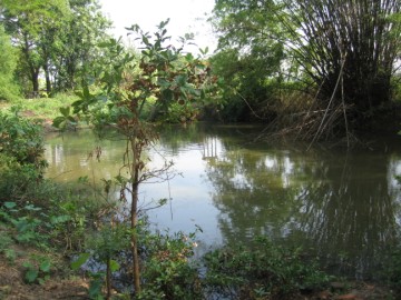
| Wat Nak appears on the Fine Arts Department map of 1993. It was located off the city island on the Phaniat peninsula. It was situated between Wat Borommawong and the Elephant Kraal, toward Khlong Bang Khuat (the old Lopburi River) to the west. The map shows it at the intersection between the road parallel to Khlong Bang Khuat and a (now defunct) road leading to Wat Borommawong. This temple's history is unclear. Other temples in this area suffered greatly during Burmese invasions. This temple has finally "disappeared" due to heavy flooding in the vicinity and general disuse. The remains are presently located on private property, which is guarded by a large group of rather fierce dogs. Locals recall seeing Wat Nak in their youth. Many remember a large head from a Buddha image. They believe it has been buried underground. Excavations could reveal some traces of a foundation and other artifacts. |

| | | | | | | | |
| Text by Ken May - March 2009 |
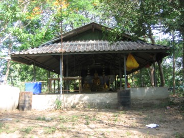
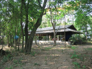
| Addendum Wat Nak or the Monastery of the Naga is located off the city island in the northern area of Ayutthaya in Suan Phrik sub-district. It can be reached by the road No 3060 leading from the Elephant Kraal to Wat Phukhao Thong. This area was called in earlier times “Thale Ya” or “Sea of Grass” as the whole area was as a large grass field. “Thale Ya” was derived from the name of the sub-district at that time, being “Thamle Ya”. The temple was situated on the north bank of canal leading from the old Lopburi River to Wat Borommawong, called Khlong Nam Ya. In situ there is still a brick mound and an ancient pond. In recent times a commemorating vihara has been put on top. In the vihara is a pedestal with three Buddha images found at location. The story goes that one day “heaven called” and local people found on the spot, a head of a Buddha image sticking out of the ground, the flame filial (ketumala) broken. The locals dug out the image, repaired the filial, built a vihara on top of the ruins of Wat Nak and gave the statue a prominent place within. The two flanking Buddha images inside the vihara were also found on site, their bodies decapitated. These images were also repaired. Historical data about the monastery and its construction is unknown. The site is located in Geo Coord: +14° 22' 47.84" N, +100° 33' 52.66" E. |
| Text & photographs by Tricky Vandenberg - May 2009 Updated May 2011, April 2013, January 2015 |
| (Vihara from the east side) |
| (Vihara from the north side) |
| (The three Buddha images) |
| (The ancient pond) |

| | | | | | | |


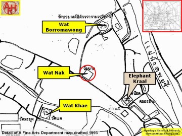
| (Detail of a 1993 Fine Arts Department map - Courtesy Khun Supot Prommanot, Director of the 3th Regional Office of Fine Arts) |
