| WAT PA SAK (วัดป่าสัก) |
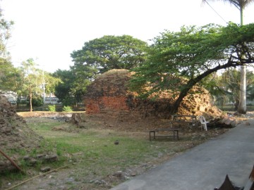
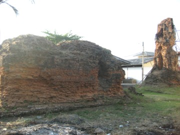
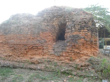
| This restored temple ruin is located on the city island along the northern part of Rojana Road. It is situated on the property of Ayutthaya Wittayalai School. Wat Pa Sak is one of the three temple ruins that are still visible at this school. The other two are Wat Mae Nang Muk and Wat Saphan Nak. There are two structures standing in situ. One of these is a medium-sized chedi. This was built in the Khmer-influenced style known as a prang. Although it has been heavily eroded, some stucco remains that give it a similar appearance as the prang at Wat Som. For this reason, it is believed by some archaeologists that Wat Pa Sak was constructed during the Early Ayutthaya period. There are a number of large holes dug into its sides, which has greatly weakened its stability Today the reliquary tower is prevented from toppling over by metal girders that hold it in place. The second structure is a bit more mysterious. It has also badly eroded. This square-like structure appears to be the elevated base of a sermon hall. The top of this base seems to have collapsed into a mound. Only a small portion of its walls and some stucco can still be discerned at the top. There are several large holes dug into the sides by looters. Interestingly, based on the positioning of these two structures, Wat Pa Sak would appear to be aligned on a north/south axis - a rare trait for monasteries in the Early Ayutthaya period. Wat Pa Sak also has a large number of Buddha images on site. Among these scattered detritus is a carved bowl-like structure. There is evidence that Wat Pa Sak was restored in the late period, which suggests it was still active at the time when Ayutthaya fell to the Burmese. There is little known about this monastery’s history. A canal once ran along an east/west axis just north of Wat Pa Sak, which provided easy access to the monastery. To its east was a small pond that also provided boat access. Additional canals around Wat Pa Sak formed a small island for this monastery to rest upon. Some traces of these canals are still visible today. Wat Pa Sak was excavated by the Fine Arts department in 2001. A Buddha image was found inside the prang as well as a variety of pottery. Possibly portions of this monastery were destroyed during the construction of Rojana Road. |

| | | | | | | | |
| Text & by Ken May - August 2009 |
| | | | | | | |


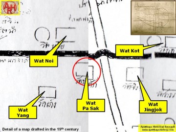
| Addendum Wat Pa Sak can be translated as the Monastery of the Teak Forest or Teak Quarter. The site is indicated on a mid-19th century map in a nearly identical position as on Phraya Boran Rachathanin's map drafted in 1926. The mid-19th century map indicates the existence of a chedi, which at present still can be seen. The site has been restored by the Fine Arts Department. The site is situated in geographical coordinates: 14° 21' 3.13" N, 100° 33' 58.23" E. |
| Addendum, Photographs and maps by Tricky Vandenberg - April 2011 Updated April 2019 |
| (View from the south) |
| (Remains of the chedi in situ) |
| (Remains of a monastic structure) |
| (Excavation hole) |
| (Objects found in situ) |
| (View from the east) |


| (Detail of a 19th century map - Courtesy of the Sam Chao Phraya Museum) |

| (Detail of Phraya Boran Rachathanin's map - Anno 1926) |

| (Detail of a 2007 Fine Arts Department GIS map - Courtesy of the Fine Arts Department - 3th Region) |
