| WAT SAPHAN THAN (วัดสะพานถ่าน) |
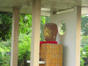
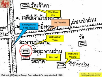
| This former monastery was located near the intersection of Chikun Road and Naresuan Road. The nearest landmark to it would be the two chedi built for Prince Ai Phraya and Prince Yi Phraya. Wat Maha That and Wat Racha Burana are situated west of this site. Wat Saphan Than is sometimes mistaken for a monastery known as Wat Chaiyaphum (also as Wat Lat). Both were located near the same location, but these are not the same temple. The two monasteries were once on opposite sides of Khlong Pratu Khao Pluak, and moats further separated them. Wat Saphan Than was located near a brick bridge that crossed Khlong Pratu Khao Phluak - and this is how it earned its name. A reconstructed portion of this bridge is still visible, but no trace of this monastery is visible above the ground today. It was partially destroyed in the process of expanding and paving Naresuan Road. It was also destroyed when portions of the canal were covered with soil. During the process of this construction, the head of a Buddha images was uncovered. This now sits on a shrine at a neighboring household. The shrine can be seen on private property east of the monastery's original site. The Buddha head is well taken care of and decorated with gold leaf. Wat Saphan Than appears on Phraya Boran Rachathanin’s 1926 map, but there is little known about its history. Markets sold charcoal, wood, and coconuts in the vicinity. Royal Chronicles do not mention a monastery by this name, but they do refer to the bridge that it was named after. When King Intharacha died in 1424, two of his sons fought for the throne in an area at the foot of Than Forest Bridge, which is translated as Sapan Than. Prince Ai Phraya set himself up at the Municipality of Maphrao Forest at the Chai Pavilion, while his brother Prince Yi Phraya set himself up at the Chaiyaphum Monastery so as to enter the city by way of Cao Phrom Market (Cushman 15). Both brothers had their throats torn open at the same time by war scythes and neither of them survived. A third brother inherited the throne instead. |

| | | | | | | | |
| Text by Ken May - September 2009 Photographs by Tricky Vandenberg |

| | | | | | | |
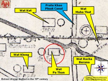
| (Detail of a 19th century map - map is orientated S-N) |
| (Detail of Phraya Boran Rachathanin's map - Anno 1926) |
| Addendum Wat Saphan Than or the Monastery of the Charcoal Bridge is also indicated on a map of the mid-19th century. The monastery is here named Wat Pa Than or the Monastery of the Charcoal Quarter. The monastery was named after the morning and evening fresh market in its vicinity selling various kinds of fruit and fresh food. The 'Pa' stands here for a market place or selling area, not for a forest. On the mid-19th century map, the monastery is curiously enough positioned north of the road leading from Wat Maha That towards Pratu Jao Jin on the Front City Canal (an extension of the ancient Palace Street). The monastery is represented with two chedi on the map. The position of Wat Pa Than is in contradiction with Phraya Boran Rachathanin's map, who puts the monastery south of the road and the Pa Than bridge. It is curious that the mid-19th century drafter of the map positioned this monastery wrong within the vicinity of a landmark such as the main road. Wat Saphan Than must have been approximately located in geographical coordinates: 14° 21' 27.70" N, 100° 34' 10.71" E. |
| Addendum & maps by Tricky Vandenberg Updated May 2015 |
| (Buddha head pavilion) |
| (Buddha head pavilion) |

| (Detail of a 1974 Fine Arts Department map - Courtesy Dr. Surat Lertlum, Chulachomklao Royal Military Academy) |
