| Text by Ken May - March 2009 Maps by Tricky Vandenberg Updated June 2015 |
| WAT SIAM RAT (วักเสียมราษฏร์) |
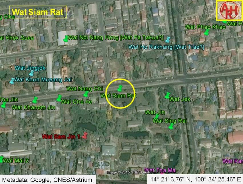
| Wat Siam Rat is a 'disappeared' temple that was once connected to a chain of Chinese pagodas north of Khlong Pratu Jin. This canal - now buried - once flowed along an east-west axis toward the Chinese Gate (Pratu Chin), intersecting with Khlong Pratu Khao Pluak (the canal that once flowed from north to south in front of Wat Maha That). The nearest modern landmark is Chiresat Witthayalai School. Wat Siam Rat appears on Phraya Boranrachthanin's (1926) map between Wat Khun Mueang Jai and Pratu Jin. However, it was dropped from the Fine Arts Department maps of 1957 and 1993. This temple can be classified as 'disappeared', and no trace of it can be found today. It may be safe to assume that Wat Cho Ae was architecturally lost sometime after (1926), though it could have remained a ruin for some time beforehand. It is not clear what this temple ever looked like. It is not certain when Wat Siam Rat was originally founded or when it disappeared. During the Ayutthaya period, a large population of Chinese maritime traders settled in this area, and this temple was situated by a road known as China Street. Engelbert Kaempfer wrote in 1727 that China Street was made of brick and included some of the best houses in the city (p 44). In addition to the Chinese population; French, Dutch, Muslim, and English merchants also resided along this road - including the Greek opportunist, Constantine Faulcon. China Street is also documented on the French map by Sieur de La Mare (1751). This temple probably 'disappeared' as a new population moved into the neighborhood during the Ratanakosin period. Khlong Pratu Jin and Khlong Pratu Khao Pluak were both buried in the rush to modernize the city. Road construction took a heavy toll during this process. |

| | | | | | | | |
| | | | | | | |
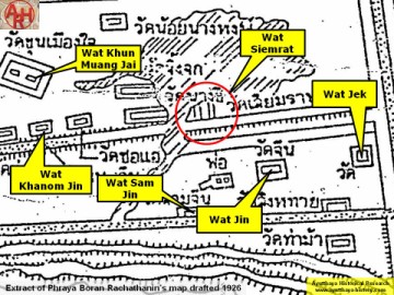
| (Detail of Phraya Boran Rachathanin's map - Anno 1926) |
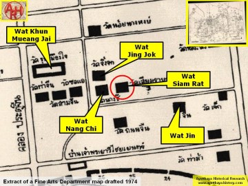
| (Detail of a 1974 Fine Arts Department map - Courtesy Dr. Surat Lertlum, Chulachomklao Royal Military Academy) |