| WAT KONG JAK (วัดกงจัก) |
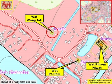
| Wat Kong Jak is located west of the main island, near the Chao Phraya River. It was once situated within the Khlong Maha Nak defensive system of canals. For the most part, this ruin consists of a brick mound; however, a small shrine has been constructed on site to protect the remains of several Buddha images. One image includes a head that has survived. A large number of bricks, pottery shards, and roof tiles are scattered around this site. Nevertheless, there are no surviving chedi, sermon halls, or boundary walls. The area is prone to heavy flooding, which has taken its toll on the former monastery. There is not much history known about this ruin. It first appears on the Phraya Boran Rachathanin map drafted in 1926. Charnvit Kasetsiri and Michael Wright point out that a Lao settlement was located in this area. They trapped and sold birds that were later released for merit [1]. However, there is no clear connection between Wat Kong Jak and a Laotian community. The impoverished neighborhood remains Buddhist for now; however Muslim populations are rapidly growing in the vicinity. References: [1] Discovering Ayutthaya - Chranvit Kasetsiri & Michael Wright (2007) - page 139. |

| | | | | | | | |


| Text & photographs by Ken May - April 2009 |
| | | | | | | |


| Addendum The defunct monastery is named after a disc-like weapon such as used by the Hindu God Vishnu; the Sudarshana Chakra with 108 serrated edges. The Sudarshana Chakra is considered to be one of the most powerful weapons in Hindu mythology. The monastery is mentioned as Wat Wong Jak on Phraya Boran Rachathanin's map. The site is located in geographical coordinates: 14° 21' 36.81" N, 100° 32' 45.70" E. |
| Addendum & maps by Tricky Vandenberg Updated March 2016 |
| (Broken Buddha images in situ) |
| (Brick work in situ) |
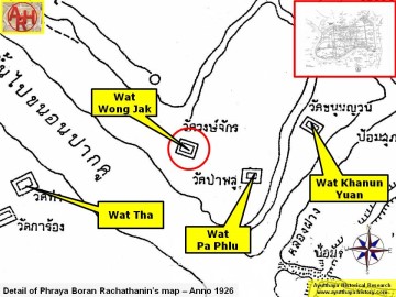
| (Detail of Phraya Boran Rachathanin's map - Anno 1926) |
| (Detail of a 2007 Fine Arts Department GIS map - Courtesy of the Fine Arts Department - 3th Region) |
