| WAT YAN SEN (วัดญาณเสน) |
| Wat Yan Sen is located beside U-Thong Road. It is situated east of the Royal Palace, and Khlong Mueang can be found on the opposite side of the road. This area is sometimes referred to as the Tha Wasukri District. Wat Yan Sen is an active monastery built on the boundaries of an ancient site. The modern facilities can be seen at the U- Thong Road entrance. The architectural structures from the ancient monastery are viewable behind the modern site. The modern temple has all the classic traits of the Ratanakosin Period, including brightly colored mirrored tiles on each of its structures. Wat Yan Sen has all the usual buildings found at an active temple (sermon hall, monk’s quarters, crematorium, bell tower, etc.). Some of the modern features that stand out are a shrine to the four-headed Erawan and an interesting deviation of a Chinese-style pagoda. There is also a large, two-tiered, bell tower featuring bells at each level. Curiously, this modern site also has whimsical statues of an elephant and other animals hiding behind trees. The most remarkable structure in situ at this temple, however, is its ancient chedi. Derick Garnier once praised Wat Yan Sen’s towering chedi as exhibiting, "the elegance and balance for which the architects of that time strove" (Garnier 45). It is designed in a similar Late Ayutthaya period architectural style as Chedi Sri Suriyothai. This chedi is entered from the east via a large staircase, and it is distinguished by its heavily indented corners and terraces. There are arched porticos in each of the cardinal directions. Each portico is crowned with its own niche and chedi. The niches have all been bricked over except for an entrance on the eastern side. The inner relic chamber is empty, but there is a hole in the floor leading to a crypt below (now sealed off). The spire has at least 49 rings and its harmika and finial are in good shape. In addition, there are several small chedis in situ. Two of which remain in relatively good condition (except for the multiple holes dug into them by looters). There are also traces of some of the old monastery walls. There is not much known about Wat Yan Sen’s history. Wat Yan Sen would have been situated behind the city’s original walls before they were expanded. This monastery probably had some type of connection to ancient elephant stables. Foreign maps show that elephants and their mahouts were housed in the area between Wat Yan Sen to Khlong Pratu Khao Pluak (Vingboons 1660; de La Loubere 1691; Coronelli 1696). Excavations revealed that a building on this site contained ropes for harnessing elephants. Wat Yan Sen was situated along Khlong Nam Chiao - a canal that brought fast-moving water from Khlong Mueang (the old Lopburi River) to Bueng Phra Ram. The water flow of this canal was regulated by a gate known as Pratu Tasibiay. A portion of the gate’s wall can still be seen along U-Thong Road near the front of this monastery. This canal was aligned with a number of temples: Wat Chum Saeng, Wat Langkha Khao, Wat Langkha Dam, Wat Sangkha Pat, and Wat Phong. During the 1940s, many artifacts were discovered at this temple, including pottery and a Buddha image in the Lopburi style. Jane Bunnag produced a map in 1973 that shows Wat Yan Sen as an active temple, whose monks walked along an alms-route to the Hua Ro market and back (Bunnag 102-103). Her research shows that Wat Yan Sen received most of its income from private donations, and that it augmented the monastery's income by renting part of its land to tenants for 50 Baht per year, which was considered quite a bargain rate at that time (Bunnag 122). |

| | | | | | | | |
| Text & photographs by Ken May - August 2009 |


| | | | | | | |
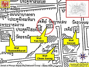
| Addendum The water flow of Khlong Nam Chiao was not regulated by the gate known as Pratu Tha Sip Bia (the Gate of the Landing of the Ten Cowries). This gate was a large land gate in the northern city wall situated near the northeastern corner of the outer wall of Wat Thammikarat. Following Phraya Boran Rachathanin (PBR) the Nam Chiao canal entered the city two entries further to the east at an entrance called Chong Maha Thera Mai Sae. The canal aligned with Wat Chum Saeng, Wat Langkha Khao, Wat Langkha Dam, Wat Sangkha Pat, and Wat Phong mentioned above was called Lam Khu Pak Sra. [1] This author believes that the local people could have called the latter Khlong Nam Chiao, but this is in contradiction with PBR's writings. Wat Yan Sen is located in geographical coordinates: 14° 21' 33.15" N, 100° 33' 49.96" E. References: [1] Athibai Phaenthi Phra Nakhon Sri Ayutthaya kap khamwinitjai khong Phraya Boran Rachathanin (2007) - Explanation of the map of the Capital of Ayutthaya with a ruling of Phraya Boran Rachathanin - Revised 2nd edition and Geography of the Ayutthaya Kingdom - Ton Chabab print office - Nonthaburi (2007) - page 53. |
| Addendum & maps by Tricky Vandenberg Updated March 2016 |
| (The chedi of Wat Yan Sen) |
| (The gable of the ordination hall) |
| (Satellite chedi in situ) |
| (The chedi of Wat Yan Sen) |


| (Detail of a 19th century map - Courtesy of the Sam Chao Phraya Museum - map is orientated S-N) |
| (Detail of Phraya Boran Rachathanin's map - Anno 1926) |
| (Detail of a 2007 Fine Arts Department GIS map - Courtesy of the Fine Arts Department - 3th Region) |

| (Source: Phra Rachawang lae Wat Boran nai Jangwat Phra Nakhon Sri Ayuthaya - 2511. Courtesy of the Fine Arts Department - 3th Region) |