| WAT YOM THAI (วัดยมไท) |

| | | | | | | | |
| Wat Yom Thai is a defunct temple formerly located off the city island in the eastern area in present Hua Ro sub-district. The monastery was situated on the present premises of Wat Tham Niyom in between Wat Nang Chi and Wat Jan, in the immediate vicinity of Wat Yom Mon. Wat Yom Thai is indicated on a mid-19th century map and features also on Phraya Boran Rachathanin's map drafted in 1926, but is named here as Wat Yom. Historical data about the monastery and its construction are unknown. The mid-19th century map indicates no chedi nor prang in its location. Wat Yom Thai and Wat Yom Mon were situated about 100 meters from each other following a Fine Arts Department excavation map drafted in 2005. Wat Yom Thai stood south of Wat Yom Mon, identical as indicated on the mid-19th century map. Some remains of the temple were excavated by the Fine Arts Department (FAD) in Geo Coord: +14° 21' 32.52" N, +100° 34' 53.31" E. |
| Text & map by Tricky Vandenberg - November 2010 Reviewed July 2011 |
| | | | | | | | |
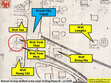
| (Detail of a 19th century map - map is orientated S-N) |