| WAT MAHA THALAI (วัดมหาทลาย) |
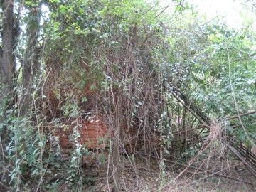
| Wat Maha Thalai is located in the Phai Ling area within a sports complex outside of the city island. The deserted monastery can be found behind a building used for sports. It is difficult to see and covered in heavy vegetation most of the time. The architectural design consists of one sermon hall. There is not a clear trace of any chedi or outer walls. However, one large wall of the sermon hall has survived. This wall is propped up by metal scaffolding to prevent it from falling over. The Fine Arts Department has made some recent restorations at Wat Maha Thalai. There is no historic record of this monastery; however, there is evidence that earth walls once passed through this southeastern area but were knocked over to make room for rice fields. This could explain Wat Maha Thalai's location at such a remote site. In 1972, construction work was suspended on an extension of an agricultural school in this area after machinery dug up the remains of at least five temples. It is therefore interesting to note that virtually all of the buildings in this sports complex were constructed above the ground without further digging. |

| | | | | | | | |

| | | | | | | |
| Text by Ken May - December 2008 |
| Addendum, maps & photographs by Tricky Vandenberg March 2016 |
| Addendum Wat Maha Thalai is indicated on a 1993 Fine Arts Department map. An information board in situ mentions that the monastic structure was of rectangular form and built in brick, measuring 7.6 x 10 meters. The temple dates from the Middle Ayutthaya period (1488 - 1629 AD). The site is situated on the horizontal axis Wat Khanan - Wat Maklam - Wat Maha Thalai - Wat Mo Hon and on the vertical axis Wat Fai Mai - Wat Sema - Wat Maha Thalai - Wat Suwimon. The site was completely restored (including a walk path, rest benches and bicycle parking facility) after the large flooding of October-November 2011. When visited in March 2016, the site was completely overgrown and in a deteriorated state, while the access to the site was hindered by a dump of construction waste. The ruins of Wat Maha Thalai are situated in geographical coordinates: 14° 20' 54.96" N, 100° 35' 56.34" E. |
| (Rectangular brick structure in situ) |
| (View of the Wat Maha Thalai site) |

| (Detail of a 1993 Fine Arts Department map - Courtesy Khun Supot Prommanot, Director of the 3th Regional Office of Fine Arts) |


