| WAT SAMANA KOTTHARAM (วัดสมณโกฏฐาราม) |
| Wat Samana Kottharam is located off the city island in the eastern part of Ayutthaya. It is easiest way to reach this active monastery by turning north at the roundabout chedi on Rojana Road (Wat Sam Plum). This temple can be easily found on the western side of the road. Wat Samana Kottharam is situated in a part of the city known as Ayodaya. It is widely believed that a Dvaravati (and Lopburi allied) settlement existed here before King U- Thong established Ayutthaya in 1351. A canal flowing in a north/south axis passed in front of this monastery. The mouth of this canal starts in Khlong Hantra (the old Pa Sak River) and ultimately leads all the way to Wat Yai Chai Mongkhon. This now defunct canal is known as Khlong Kudi Dao today, and Wat Samana Kottharam was situated on its western bank. Wat Samana Kottharam is an active temple with portions of ancient buildings still in situ. One of its oldest structures is a unique bell-shaped chedi, which could date as early as the 14th -15th century. There is also a portion of a second chedi on site, but it has greatly eroded. Its relic chamber and spire no longer exist. Still, based on the remaining structure and its multiply indented corners, this Khmer-influenced prang may have been designed in a style dating to the late Ayutthaya period, but this topic is still under debate. One ancient sermon hall has been restored to the basic foundation level, and a large Buddha image has been placed on its altar. There are other ancient structures in situ, but all have also eroded to the basic foundation level. Modern Buddha images in various styles have been placed on the altars. The most interesting Buddha image is standing with his right arm raised and palm pointed outward in a Halting Evil pose. The wheel of Wat Samana Kottharam also has an active ordination hall. This ubosot has been build on the remains of an older construction. It is still possible to see the earlier building’s foundation layer, some of its walls, and a few pillars. The modern ubosot has incorporated them into its current structure. The front portico of this ubosot is designed in the Late Ayutthaya period style. There are a significant number of Buddha images inside. Since Wat Samana Kottharam is active with a fully functioning Buddhist clergy, the monastery has all the other structures needed for day-to day operations. The history of Wat Samana Kottharam is unclear. Written accounts are vague and require further investigation. It is implied that Royal Chronicles refer to this monastery during the reign of King Narai (1656-1688). A man named Chao Phraya Kosa Lek supposedly restored this temple after leading Siamese troops in an attack at Chiang Mai. By some accounts, King Phetracha led a procession to this monastery for the cremation of his wet nurse, Chao Mae Dusit, who was also the mother of Kosa Pan and Kosa Lek (TAT 116-117). However, this same funeral has also been reported as taking place at Wat Choeng Tha, and it may have even happened at Wat Pradu Songtham instead (see link to the latter monastery). The first time that Wat Samana Kottharam is specifically mentioned by name is by a French visitor, Simon de La Loubère. The temple is referred to in a most unusual story about a Mon from Pegu who self-immolated himself at Wat Sam Vihan due to a family dispute. The Mon sat cross-legged and smeared thick oil over his entire body. After he ignited the fire and his body thoroughly charred, his mother had it coated with plaster and a gilded statue was made from it. The statue was then put on an altar at Wat Samana Kottharam (de La Loubère 127). However, it is another foreign visitor who usually gets cited inaccurately for producing information about Wat Samanakottharam - even though he has never mentioned a temple by this name. The foreigner was Engelbert Kaempfer. He came to Ayutthaya in 1690 as a German physician for the Dutch East Indian Company (VOC). Although he stayed in Ayutthaya for less than a month, Kaempfer developed a well-detailed field map consisting of several drawings glued together onto a large base. It had elaborate details about geography, palaces, temples, bridges, and shop houses. In 1727, Johannes Gaspar Scheuchzer published a book that featured two additional maps that Kaempfer is accredited for post-mortem. One map shows the route from the Gulf of Siam to the capital city, and the second has detailed outlines of the city’s roads and canals. Both maps feature a monastery east of the city island known only as “The Courts of Berklam’s Temple”, and Kaempfer wrote about it in elaborate detail. The word “Berklam” (and “Barcalon”) is a corrupted foreign version of the title Phra Khlang, essentially the Minister of Foreign Affairs and Trade. King Petracha (r.1688-1703) ruled the city during Kaempfer’s visit and Kosa Pan served as his Phra Khlang. While this foreigner was visiting the city, a funeral ceremony with great pomp was held for King Narai’s wet nurse (the mother of Kosa Pan and Kosa Lek). The place where she was cremated is described as “seated between two branches of the river on the opposite to the City, and enclos’d with a square row of Banners, Flags, and other Ornaments … upon the middle of the place was erected a stately tower of an extraordinary height, curiously adorn’d and supported by fine pillars, columns, and cornishes” (Kaempfer 21-22). Kaempfer also specifically describes the “Berklam” temples as "a double square joining together, and situate not far from the City towards the East; each square contains several Temples, Convents, Chapels, Columns, Pyramids, and other Buildings of different forms. They are separated by a Canal, and each enclos’d with a fine wall" (Kaempfer 54-62). He accompanies this initial description with a detailed plan of the temples and a vivid description (with drawings of the structures and art) – and it is probably due to mistranslation of this section that Wat Samana Kottharam gets inaccurately folded into the discourse. Kaempfer writes about the second square of Berklam’s temple as having walls full of flower boxes and plants. This site had several “Topoo” trees in situ that bore round fruit that only bats could eat. He commented that the Siamese “hold it to be holy, and pleasing to the Gods, for as much as their great Saint Sammana Khodum always chose to sit under it, and for this reason they love to plant it near their temples, if the Soil and Climate will allow it” (Kaempfer 60). Kaempfer was referring to the Buddha instead of the name of the monastery. Based on the layout of the city canals, the “Berklam” temple that Kaempfer refers to is most likely to be Wat Pradu Songtham. Wat Pradu Songtham is a perfect fit according to Kaempfer’s maps. Both maps depict four canals on the eastern side of the city. These are known today as Khlong Suan Phlu, Khlong Khao San, Khlong Ban Bat, and Khlong Pradu Songtham (as listed from south to north geographically). Kaempfer also adds a note at the mouth of Khlong Suan Phlu that this particular arm of the river was called “Klang Patnam Bija”. Although Kaempfer doesn’t specifically name the northernmost canal, its geographic position is in the exact same location as Khlong Pradu Songtham. Moreover, Kaempfer’s maps clearly show that the Berklam temples hold a corner position along the west bank of a canal running in a north/south axis. This canal is known today as Khlong Ayodaya. In contrast, there is no trace of a canal running past Wat Samana Kottharam in an east/west axis. The monastery was only accessed by boat via Khlong Ayodaya, which flows from north to south. Furthermore, Wat Samana Kottharam is situated much further south than Wat Pradu Songtham – exactly between Khlong Ban Bat and Khlong Pradu Songtham. This is the wrong spot to match any of Kaempfer’s maps. Furthermore, Kaempfer clearly points out that on land the “Berklam’s” temple is a double square, or two separate monasteries, with a small canal separating them. However, there are no temples opposite of Wat Samana Kottharam. The 1993 FAD map doesn’t list a single monastery beside it, or even a brick mound for that matter. The closest monastery to Wat Samana Kottharam is Wat Khao Din, but the latter is still in the wrong location to match Kaempfer’s description. In contrast, Wat Pradu Songtham has several temples close enough to be viewed by a foreign visitor as being attached. Wat Jakrawan is immediately east; and Wat Kudi Dao is directly south. It is plausible that Kaempfer considered Wat Jakrawan to be adjacent to Wat Pradu Songtham. A small moat once separated the two temples, and Wat Jakkrawan has a general layout and a large bell-shaped chedi that could reflect the ones drawn on Kaemper’s plan. The structures drawn by Kaempfer are, of course, much different than the ruins in situ. Nevertheless, there is enough evidence on his maps to suggest that Wat Samana Kottharam has been incorrectly identified. At any rate, more analysis needs to be placed on this issue by future researchers. |

| | | | | | | | |


| Text by Ken May - September 2009 |
| | | | | | | |
| Addendum The word "Sramana" meant originally, in the language of the Brahmins, "a man who performed hard penance" (from "sram" - to work hard). The word was changed when it became the name of a Buddhist ascetic or monk; sramana was pronounced samana (from the Sanskrit root "sam" meaning "to quiet", which in Pali becomes likewise "sam") and is said by the Buddhists to mean "one who tames the senses, or has quieted the evil in him". This explanation, commonly given in European works on Buddhism, is wrong. [1] Referring to the name of the monastery Wat Samana Kottharam, we see that the Sanskrit suffix "tharam" has been added and used for a comparative degree ("viryavat" means "strong", "viryavat tharam" means "stronger") [2]. The initial name thus was Wat Samana Kot, possibly referring to Samana Khodom or Gotama/Gautama, the Buddha. References: [1] The Wheel of the Law - Alabaster Henry (1871) - page 203. [2] Sanskrit Grammar by William Dwight Whitney. |
| Photographs, map & text by Tricky Vandenberg - May 2010 Updated April 2015 |


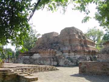
| (View from the east) |
| (Buddha statue on the remnants of a monastic hall) |
| (Old ordination hall with chedi) |
| (View of the main chedi) |

| (Fine Arts Department board in situ) |

| (Detail of a 2007 Fine Arts Department GIS map - Courtesy of the Fine Arts Department - 3th Region) |
