| Text by Ken May - March 2009 Map by Tricky Vandenberg |
| WAT SINGHA SAI |
Wat Singha Sai might be a disappeared temple. It appeared on Phraya Boran
Rachathanin's (1926) map. It was also listed on the Fine Arts Department tourist map of
1993. There are some contradictions as to its exact location. Nevertheless, this temple
would have been located along Khlong Nai Kai (Khlong Makham Riang) on the
property of where a Women's Dormitory stands today. Khlong Pratu Jin - now buried -
once flowed through this area along an east-west axis toward the Chinese Gate (Pratu
Jin).
It isn't clear when Wat Singha Sai was originally founded. Chinese maritime traders
settled in this harbour/warehouse area along a road known as China Street. China Street
is documented on the French map by Sieur de La Mare (1751). Engelbert Kaempfer
added in 1727 that China Street was made of brick and included some of the best
houses in the city (p 44). In addition to the Chinese population, these houses also
belonged to French, Dutch, Muslim, and English merchants.
It is not clear what this temple looked like. No trace of it can be seen for certain. There
exists a rectangular mound just north of Wat Tha Ma in which a temple was once
located. There are a few sections of Buddha images stacked next to a tree as evidence.
There is also a second rectangular mound to the west of this site, but it has eroded down
to only a few bricks. One of these sites might be the remains of Wat Singhasai, but more
research is needed to be sure.
This temple probably "disappeared" as a new population moved into the neighborhood
during the Ratanakosin period. It may have also been a casualty of road construction in
the area. Given its location near the harbour, it could also have been a casualty from the
period in which King Rama I and King Rama III removed bricks to Bangkok to build a
new capital.
During the post-Ayutthaya period, a teacher training college for women was located
close by. This explains why this old temple is situated on a women's dormitory property
today.

| | | | | | | | |
| | | | | | | | |
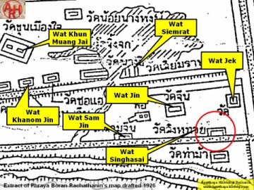
| (Extract of Phraya Boran Rachathanin's 1926 map) |