| WAT TRAI TRUENG (วัดไตรตรึงษ์) |
| Wat Trai Trueng is a reconstructed ruin located on Ayutthaya's city island in the Historical Park in Pratu Chai Sub-district. The monastery is situated in the vicinity of Wat Phra Ram, established on the cremation site of the first Ayutthayan monarch King U-Thong, officially called Ramathibodhi I. The ruin is located in Bueng Phra Ram - north of Pa Thon Rd and the Ayutthaya Witthayalai School. In situ is an east-directed sermon hall (vihara) with a chedi on its western side. There are also a number of foundations of chedi rai (satellite chedi) remaining. Its historical background and period of construction are unknown. The "Master Plan for Tourism Development of Phra Nakhon Si Ayutthaya and the Neighbouring Provinces" mentions that there were no remains of this temple. The document stipulates that there were only three temples left in Bueng Phra Ram in 1988, all in poor condition, being: Wat Nok, Wat Song Pat (likely Wat Sangkha Pat) and Wat Langkha Dam. The ruin of Wat Trai Trueng we see today, must have been completely reconstructed. [1] The temple could be named after the City of Trai Trueng, a settlement in the area of Kamphaeng Phet on the Ping River (one of the major tributaries of the Chao Phraya River) established by a group of Thai from the area of Chieng Saen, who were expelled by the Burmese in the latter part of the twelfth century. The city became likely a vassal to Sukhothai in the middle of the thirteenth century. The city was said to be once the home of the mother of King U-Thong. The princess was expelled from the city by her father, the King of Trai Trueng, after having married a commoner. They both left the city and established Thep Nakhon in 1319. In 1344, their son U-Thong became king and moved the capital to Ayudhya in 1351 (based on the work of Somdet Phra Wannarat, the Culayuddhakaravamsa). [1] The ruin of Wat Trai Trueng is located in geographical coordinates: 14° 21' 12.04" N 100° 33' 49.42" E. References: [1] Master Plan for Tourism Development of Phra Nakhon Si Ayutthaya and the Neighbouring Provinces - Tourism Authority of Thailand - 6 August 1988 - page 4-58. [2] The Rise of Ayudhya - Charnvit Kasetsiri (1976) - page 56. |

| | | | | | | | |


| Text & photographs by Tricky Vandenberg Updated March 2016 |
| | | | | | | |

| (View of the hall from the west) |
| (View from the southeast) |
| (View from the south) |
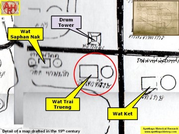
| (Detail of a 19th century map - Courtesy of the Sam Chao Phraya Museum - map is orientated S-N) |
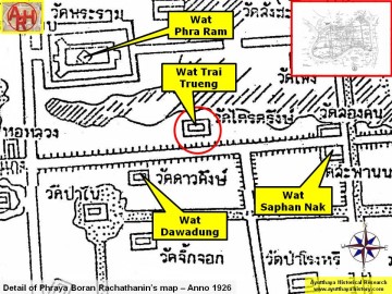
| (Detail of Phraya Boran Rachathanin's map - Anno 1926) |

| (Detail of a 2007 Fine Arts Department GIS map - Courtesy of the Fine Arts Department - 3th Region) |


