| WIHAN KLAEP (วิหารแกลบ) |
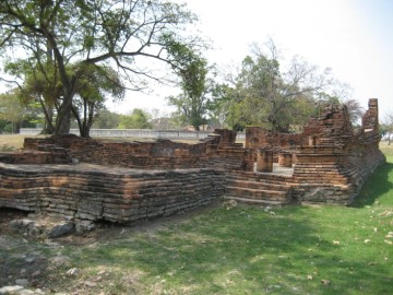
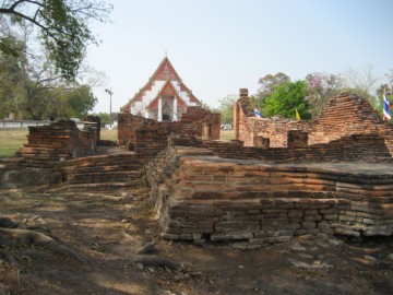
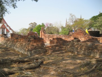
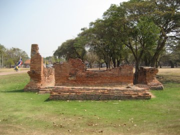
| Wihan Klaep of the Vihara of the Paddy Husk is located east of Wihan Phra Mongkhon Bophit. Historians assume that this ruin was part of Wat Chi Chiang Sai, built by King Chairacha (r. 1534-1547) in 1538. This temple housed before Phra Mongkhon Bhophit and was at that time already legendary. [1] Jeremias Van Vliet, a Dutch merchant wrote the following in 1638: "Previously I mentioned that Phra Chaiyaracha, thirteenth king of Siam, built the temple Phra Chi Chiang, from which place many miraculous things are reported to have occurred. Since these tales are too fabulous, I beg to be excused from relating them. This temple was at one time the largest and the highest of the entire kingdom, but it has been knocked down as a result of lightning and thunderstorms through the years. Many kings undertook to rebuild this temple, but as soon as work began, they had to abandon it because the foremen and laborers were struck by numerous illnesses and died pitifully It was also said that the Brahmans and the monks have a prophecy that this temple can only be repaired by a king who is descended from the pure old family and rightful line of the Siamese kings." [2] King Prasat Thong (r. 1629-1656) ordered in 1639 the ruins of Wat Chi Chiang cleaned up and its main Buddha image Phra Mongkhon Bophit - moved to a location more west of the temple, with the intention to rebuild the temple and to prove - at the eve of the year 1000 of the Chula Sakarat era - he was a rightful king. Most important clerics - Brahmans - although believed that the king's act rather had to be defined as treasure hunting. Jeremias Van Vliet, continued in his "Description of the Kingdom of Siam": "A few months ago the ruling king demolished the temple to its very base and had a large copper heathen image which was located there pulled back several rods so that another temple like the last could be built over the image. …However, the Brahmans say that they have seen in the signs in the heavens, that His Majesty would not complete the newly-begun temple but would die before its completion, principally because the rebuilding was not begun out of pure devotion, but out of His Majesty’s hope of finding great treasures in the demolition of the former temple." [2] King Prasat Thong although, did finally not rebuild Wat Chi Chiang Sai and survived the temple’s curse - he died of old age in 1656. He had the location of the temple leveled, being reserved for royal cremation ceremonies. (called Sanam Na Chakkrawat) Wihan Klaep is likely the sole witness of this once legendary temple. The site is located in geographical coordinates: 14° 21' 17.54" N, 100° 33' 33.98" E. References: [1] The Royal Chronicles of Ayutthaya – Richard D. Cushman (2006) - page 20 / Source: Luang Prasoet, Phan Canthanumat, British Museum, Reverend Phonnarat, Phra Cakkraphatdiphong & Royal Autograph. [2] Van Vliet's Siam - Chris Baker, Dhiravat Na Pombejra, Alfons Van Der Kraan & David K. Wyatt (2005) - page 157, 243, 244. |

| | | | | | | | |
| In 900, a year of the dog, the King first had the earth piled up at the Chi Chiang Sai Monastery in the sixth month , and founded the Lord Buddha image and the holy monument there … |
| Text, maps & photographs by Tricky Vandenberg Updated March 2016 |
| | | | | | | |
| (View from the east) |
| (View from the south-east) |
| (View from the east) |
| (View from the west) |
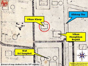
| (Detail of a 19th century map - map is orientated S-N) |
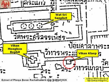
| (Detail of Phraya Boran Rachathanin's map - Anno 1926) |
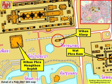
| (Detail of a 2007 Fine Arts Department GIS map - Courtesy of the Fine Arts Department - 3th Region) |
