
| KHLONG KHU CHAM (คลองคูจาม) |
| Text, maps & photographs by Tricky Vandenberg Updated April 2016 |
| | | | | | |
| Khlong Khu Cham or the Cham Canal is an existent canal situated off the city island in the southern area of Ayutthaya running through the Samphao Lom and Khlong Takhian sub-districts. The canal splits off from the present Chao Phraya River (1) about 500 meters east of Wat Phutthaisawan and runs south to join Khlong Takhian, nearly at the latter’s confluence with the Chao Phraya River. The Pratu Chakra Noi Fortress, situated on the city island to the east of Khlong Chakrai Noi, stood opposite the entry of Khu Cham and controlled the in-and-out traffic of the latter. (2) [1] At the entry of Khlong Khu Cham on its east bank, stood Wat Thong, while on the opposite side of the canal stood a prayer house (Surau Khaek). The southern area of Ayutthaya is shaped by Khlong Takhian and the Chao Phraya River; and separated into two areas by Khlong Khu Cham. The eastern area was populated by the Chinese (around Bang Kaja) and Portuguese trading communities along the west bank of the Chao Phraya River. The western area was inhabited by Cochin Chinese refugees - mostly Christians, while the Malay occupied the southern area. Cham Muslims from Cambodia and Vietnam settled in between these areas along Khlong Khu Cham, probably called Rivière du petit Cochan by the French. Cochan is likely the French contorted pronunciation of the Thai word Khu Cham; Petit stands for small, meaning that also Khlong Takhian was denominated by the French as Khu Cham (Rivière du Grand Cochan). At the confluence of the Chao Phraya River and Khlong Khu Cham, behind the Surau Khaek, was the Pak Khlong Khu Cham floating market, one of the four large water markets of the city. [2] Muslim merchants from Java and Malaya anchored their "Rua Pak Khwang" (wide mouth boats) with a beam of 5 to 6 meters (3) in front of the mouth of the canal to sell loads of betel nut, rattan palm baskets, pandan canopies (4) and many other things from the south. [3] The canal received its name because it runs mainly through an area formerly inhabited by the Cham. The Cham arrived on the Indochina coast by sea 2000-2500 years ago, and were one of the great Austronesian seafaring groups; speaking Cham, a Malayo- Polynesian language. Hinduism was at first the predominant religion of the Cham, replaced later by Mahayana Buddhism. The Kingdom of Champa, a generally said Indianized kingdom established in the 7th century, covered a territory, what is at present southern and central Vietnam. Champa reached its apex in the 9th and 10th centuries. Today scholars believe that Champa was likely never a unified polity, but a number of strategically located river-mouth centers which developed, competed with one another, and declined according to the fluctuations of international trade. [4] Viet troops attacked and conquered the northern Cham polity with its capital Vijaya in March 1471. The defeat caused the first major Cham emigration, particularly to Cambodia and Melaka. From the Malay Annals we know that the Cham refugees were well received by the rulers of Melaka, who appointed some Cham noblemen to official positions in the court. The Cham in Cambodia, helped by local Malay communities, were also allowed to hold governmental posts and to serve in the army. But in 1659, after a military intervention of the Viet followed by internal struggle, Malays and Cham were expelled from Cambodia and took refuge in Siam. Although Islam was likely already introduced in Champa in the late 10th century [5], the religion became more dominant after the fall of Vijaya, as the Chams were leaning more and more towards the Malay Peninsula for their struggle against the Viet. French missionaries in the 17th century wrote some accounts regarding the presence of the Malay missionaries and their role in spreading Islam at the court of Champa. [6] In September 1692, the southern Cham principality of Panduranga (present Phan Rang) - after having strengthened its position against the Vietnamese through dealings with other regional powers - challenged the Vietnamese Nguyen family, ruling southern Vietnam since 1558. The campaign ended with the defeat of the Cham in the first month of 1693. A series of battles between the remnants of Cham forces and the Vietnamese in 1693-94 left the area in severe famine and led to the outbreak of plague. In 1694, the kingdom of Champa ceased to exist as an independent entity and was integrated into the Nguyen domains. After the fall of the southern principality, the Cham, losing their homeland, turned towards the Malays of the peninsula for assistance. This eventually triggered the major shift in religious orientation of the Cham so that by the time of their final annexation by the Vietnamese, the majority of the Cham people had converted to Islam. [7] In the Royal Chronicles of Ayutthaya we find already at the beginning of the 15th century an indication of the existence of a Cham village. In 1409, King Ramaracha (reign 1395- 1409) ordered the arrest of Chao Phraya Senabodi, one of his main ministers. The latter was able to escape the king's wrath by crossing the Lopburi River to Patha Khu Cham. Later the minister supported King Intharacha, a cousin of Ramaracha and Ruler of Suphanburi, in a fight for the throne. After King Intharacha (reign 1409-1424) assumed the throne, he banished his cousin to live in Patha Khu Cham. "Patha" is a Khmer word meaning "camp" or "village"; thus, Patha Khu Cham can be translated as the "Village of the Cham Canal". The Cham settled east of Wat Putthai Sawan on the west bank of Khlong Khu Cham. [8] “In 771, a year of the ox, King Ram was enraged at Cao Senabòdi and ordered that he be arrested. Cao Senabòdi fled to safety and went across to stay on the other side of the river at Pathakhucam. Cao Senabòdi then sent messengers to invite Prince Intharacha to come from Suphanburi and to tell him that he would bring troops in and seize Ayutthaya for him. When Prince Intharacha arrived, he then ordered Cao Senabòdi to lead his men in and they attacked and captured Ayutthaya. So Prince Intharacha was invited to ascend the royal throne and he sent King Ram to live off Pathakhucam.” [9] Following the Royal Chronicles, a Cham village existed already in 1409, prior to the fall of the northern Cham locality Vijaya in 1471. The Cham were prolific traders and specialized in trading far beyond their localities. The Cham in Ayutthaya were as thus probably not refugees, but a colony of traders. At that time they (likely) were also Buddhists and not Muslims (for example the rulers of Melaka converted to Islam only in 1414). Patha Khu Cham seems also to have been an isolated place and this concur with the distinct cultural identity of the Chams in pursuing active isolationism. [10] A reason why the dethroned King Ramaracha was expelled to live in their midst. More Cham refugees joined the settlement in Ayutthaya due to political problems caused by the Vietnamese invasion of the Kingdom of Champa at the end of the 16th century, as explained above. Additionally, Cham migrated to Cambodia were taken prisoner when the Siamese army invaded the country. When more Cham refugees arrived, the community expanded to settle along both banks of the Khu Cham and formed a farming society, growing floating rice on the banks of the canal near their villages. [8] After a Mon insurgency in Martaban in 1662, more than 10.000 Talaings escaped from Hongsawadi to Siam via the Three Pagoda Pass. A front guard advanced to Kanburi in order to give account of the occurrences to King Narai. The King sent some thousand Mon troop to meet them and to guide the refugees to Kanburi. The Mon nobles were received for an audience at the court and arrangements were made to harbour the families in the vicinity of Sam Khok, partly near Khlong Khu Cham in the vicinity of the Monastery of the Mud of the Shell Harbor and partly in the neighborhood of the Monastery of the Card Slap. [12] The Holy Feet of the Supreme Paramount Reverence and Holy Buddha Lord of the Albino Elephants, being informed of the developments, manifested His holy satisfaction by ordering that the former Raman saming in the Capital be sent out with one thousand soldiers to meet the households of the Municipality of Martaban and bring them in to the Holy Grand Metropolis. Then the King manifested His holy compassion by being pleased to send the group of Mon families to build homes and live partly in the Vicinity of Three Knolls, partly on the Canal of the Cham Moat, and partly in the neighborhood of the Monastery of the Card Slap. Then the King was pleased to have all eleven of the saming district masters enter for an audience to prostrate themselves and render homage. The King manifested the constant condition of His holy grand compassion by making them holy royal gifts of paraphernalia of rank, household articles, clothes and seal silver, and even of dwelling sites, so they might live in happiness. Along the northern part of Khlong Khu Cham there were quite a lot of Buddhist temples. From North to south on its west bank stood Wat Noina, Wat Tawet, Wat Tama, Wat Bandai Nak and Wat Kaeo Fa, while on its east bank were Wat Thong, Wat Khok Sung, Wat Wihan Khian and Wat Tha Hoi. The Khu Cham Cemetery is found on the west bank of Khlong Khu Cham. Locals stated that the cemetery was built on the former site of a Buddhist temple. A 1993 Fine Arts Department map [12] indicates Wat Thong in this position, but a recent map repositions this temple on the east bank of Wat Khu Cham, more or less opposite of the graveyard. The main sala of the graveyard seems effectively to be built on an ancient brick foundation and brick are shattered all over the place. This brick remains could have belonged to the former Surau Khaek, but more information need to be gathered on this issue. Archaeological excavations at the site of Wat Tawet unearthed a flight of stairs leading to the Khu Cham Canal. The stairs end up about 3 meters below the road on the right bank and about 10 meters away from the present canal bank. The canal must have been as thus far much wider than we see today. Khu Cham is indicated on François Valentyn's map (1724-6) Groote Siamse Rievier Me-Nam Of Te Moeder Der Wateren In haren loop met de vallende Spruyten Verbeeld. The right bank of the river shows on the map 47. de Moorse Tempel. being a mosque (Moorish Temple). The latter must be the Surau Khaek mentioned on a mid-19th century map. Footnotes: (1) In the Ayutthayan era, the present Chao Phraya River was in fact the Lopburi River. See the essay: Ayutthaya's Ever-changing Waterways. (2) Most of the fortresses stood at the confluences of rivers and canals around the city. (3) "Sok" and "Wa" are Thai measurements. The text cites "10 Sok 3 Wa". A Sok or elbow is approx 50 cm, while a Wa is 2 meters. (4) "Krachaeng" are panels woven from pandanus leaves or nipa palm leaves, packed between bamboo and used as a cover against sunshine and rain; as a roof for houses and carts or as cover for temporary houses. [11] References: [1] Phanna phumisathan Phra Nakhon Sri Ayutthaya: Ekasan jak Ho Luang - Geographical description of Ayutthaya: Documents from the palace - Dr Vinai Pongsripian - Bangkok (2007). [2] Ibid - page 84. [3] Ibid - page 93. [4] ARI Working Paper No. 27 - Cambodia and Its Neighbors in the 15th Century - Michael Vickery (June 2004) page 6, 57. [5] The Introduction of Islam into Champa - Pierre Yves Manguin - JMBRAS, Vol. LVIII, Part 1, 1985, page 1. [6] See the letters of De Courtaulin, Mahot found in Archives des Missions Etrangeres de Paris (AMEP), Vol. 734, and letters by the Bishop of Heliopolis, AMEP, Vol. 735, pp. 198-200. [7] Vietnam-Champa Relations and the Malay-Islam Regional Network in the 17th–19th Centuries - Danny Wong Tze Ken (2004). [8] Muslim communities during the Ayutthaya period - Julispong Chularatana - page 8, 96, 97. [9] The Royal Chronicles of Ayutthaya - Richard D. Cushman & David K. Wyatt (2006) - page 14. [10] Economy in Motion: Cham Muslim Traders in the Mekong Delta - Philip Taylor (2006) - The Asia Pacific Journal of Anthropology Vol. 7, No. 3, December 2006. [11] พจนานุกรมสถาปัตยกรรมและศิลปะเกี่ยวเนื่อง ศาสตราจารย์โชติ กัลยาณมิตร (2005) - page 21. [12] The Royal Chronicles of Ayutthaya - Richard D. Cushman (2006) - page 256-8 / Source: Royal Autograph - Events in Ava - War with China. [13] FAD 1993 map - courtesy Khun Supot Prommanot - Director of the 3th Regional Office of Fine Arts. |
| | | | | | | |


| (Khlong Khu Cham on an aerial map) |
| (Khlong Khu Cham on a 1945 aerial map) |
| (View of Khlong Khu Cham, largely silted) |


| (View of Khlong Khu Cham, largely silted) |
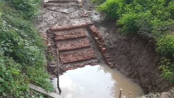
| (View of the flight of stairs excavated at Wat Tawet) |
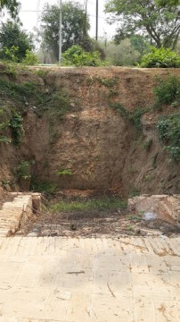
| (View of the flight of stairs excavated at Wat Tawet) |

| (Detail of François Valentyn's map published in 1726) |
