| | | | | | | |
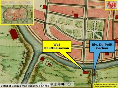
| KHLONG WAT PHUTTHAISAWAN |
| Text & maps by Tricky Vandenberg - May 2017 |
| | | | | | |
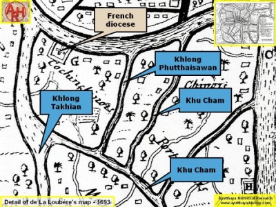
| The canal next to Wat Phutthaisawan is only found on the French maps of Ayutthaya, being the ones of de La Loubère and Bellin; both are likely based on the sketch of the French Engineer de La Mare made in 1687. On Bellin's map, it is called Rivière du Petit Cochan, while Khlong Takhian bears the name of Rivière du Grand Cochan. Some of these maps have "Cochon" instead of "Cochan", while in the work of Tachard (1689) figures "Cachon". Cochon, Cachon or Cochan, all words are the French pronunciation of the Thai word Khu Cham (Moat of the Chams). On de La Loubère's map, A Map of the Citty of Siam, the canal is indicated as the eastern border of the Cochin-Chinese settlement, running nearly parallel with another canal, which I believe must be Khu Cham. The canal ends in a north-western extension of Khu Cham, linking up further on the southern side of the settlement with Khlong Takhian. |
| On Bellin's map, we find the origin of the canal situated on the opposite side of the Victory Canal between the mouths of Khlong Chakrai Yai and built for King Narai's (reign 1656-1688) deceased queen and presumably finalized around 1685-1686. |
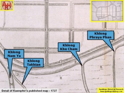
| The canal is not found on the Vingboons painting, neither on the maps of de Courtaulin (1686), De Graaff (1690) or Kaempfer (1727). It is as thus remarkable that this canal does not figure on Kaempfer's published map as he surveyed the area in 1690. Kaempfer's map has four waterways on the opposite bank of the south side of Ayutthaya. These are, based on their positions vis-à-vis the city of Ayutthaya: Khlong Nam Ya and Khlong Takhian near the French diocese; Khlong Khu Cham, opposite and slightly east of Pratu Chakrai Noi in front of the Chakrai Noi Fortress; and Khlong Phraya Phan, opposite Pratu Khao Sami. The more, all the positions of the above canals are correct based on today's satellite imagery. Kaempfer shows the northern border from the Cochin-Chinese settlement from Khlong Takhian until Khlong Phraya Phan (marked with the letter R on the map). |
| Conclusion Khlong Phuttaisawan's existence is not confirmed, although it is mentioned on Bellin's map as the "Little Khu Cham". Nevertheless I am of the opinion that there could have been a canal because I trust that the French were familiar with the boundaries of their settlement; additionally, there are some water stretches still existing in the area today, which could have been part of this canal. The waterway could have been dug at the same time of the construction of Wat Phutthaisawan. As thus either the canal existed, or the French maps must be incorrect. In the latter case "Little Khu Cham" on Bellin's map could refer to Khu Cham itself (with Wat Phutthaisawan wrongly positioned), while the canal on its east would then be Khlong Phraya Phan, a situation identical to Kaempfer's map. |