| WAT SRI JAMPA (วัดศรีจำปา) |

| | | | | | | | |
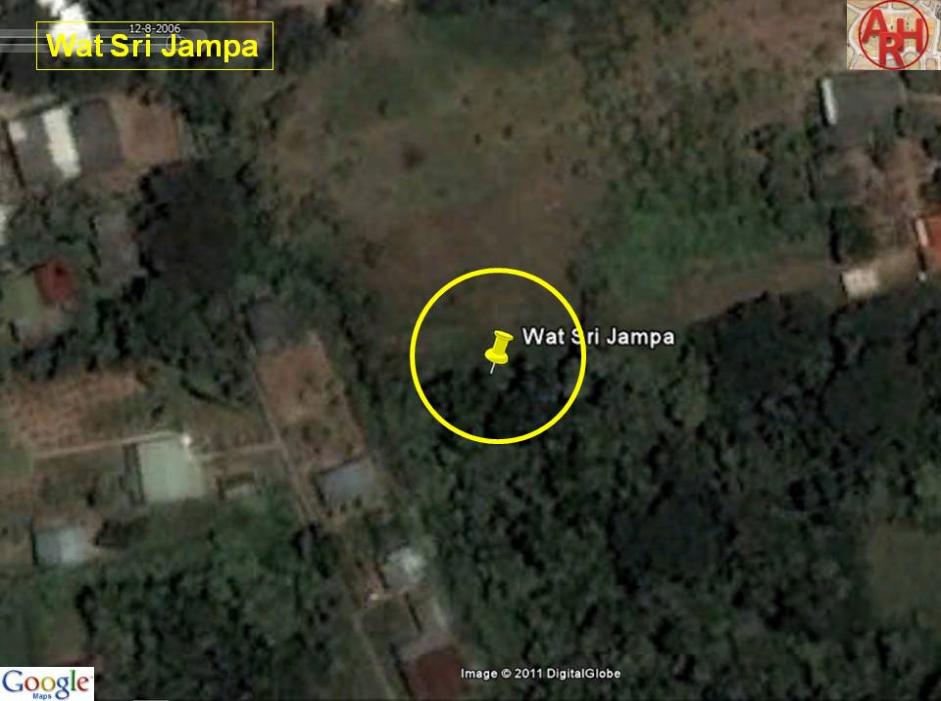
| | | | | | | |
| Wat Sri Jampa or the Monastery of the Magnificent Champer(1) was situated off Ayutthaya's city island in the northern area in Hua Ro sub-district on Ko Loi (2); a small island in front of the Chantra Kasem Palace. The temple is shown an a Fine Arts Department map drafted in 1974 (FAD 74) and was positioned east of Wat Khae and north of Wat Khao San Dam. The monastery stood not on the canal bank of Khlong Sai (at present the Pa Sak River). The temple was repositioned on a Fine Arts Department map drafted in 1993 (FAD 93) more south, more or less on the premises of the present Ayutthaya Ship Building Industrial and Technology College (ASBITC) and along the Khlong Sai canal bank. Phraya Boran Rachathanin does not mention Wat Sri Jampa on his map drafted in 1926. Professor Khemnad in his booklet on Wat Monthop, positions also Wat Jampa on the ASBITC site. [2] In order to find out more information on the monastery, author made a visit to the area in May 2011. Different villagers confirmed Wat Sri Jampa to be in the location as mentioned on the FAD 1974 map. An elder woman recalled to have seen the chedi and structure of this temple in front of her premises, but added the structures crumbled due to flooding. [3] Wat Sri Jampa stood following the information received, in geographical coordinates 14° 22' 4.79" N, 100° 34' 43.83" E. Why the FAD 1993 map and Professor Khemnad positioned Wat Sri Jampa on the premises of the ASBITC remains a still unresolved question. To my knowledge, the site has never been excavated Wat Sri Jampa was one of the seven monasteries on Ko Loi. The other temples were: Wat Monthop, Wat Khae, Wat Ngu, Wat Khao San Dam, Wat Inthawat and Wat Saphan Kluea. Footnotes: (1) จำปา - Champer or Orange Champak. Michelia Champaca (scientific name) is a large evergreen tree native to South Asia, Southeast Asia and some parts of China. It is primarily cultivated for its timber. The Champaca is related to Magnolias but the flowers are not as nice, but heavily scented. The flowers occur in varying shades of cream to yellow-orange and are used for worshipping at temples, before worn in the hair by girls for its natural perfume and used to be floated in bowls of water to scent a room. (2) Ko Loi or "Floating Island" is surrounded in the north by Khlong Chong Lom, in the east by the Pa Sak River and in the west by the (new) Lopburi River. Khlong Chong Lom has been dug in the early 20th century to reduce the whirlpools near Wat Tong Pu and the Chantra Kasem Palace, separating Wat Chong Lom from the eastern mainland. As the Lopburi River and the Pa Sak River were joining near Wat Tong Pu and the erosive force of the two rivers were destroying the embankment in front of the Chantra Kasem Palace, the idea rose to deviate the Pa Sak River. This was done shortly after the digging of Khlong Chong Lom. Khlong Sai, a small canal cutting through the eastern main land, from Wat Chong Lom to the present Ayutthaya Ship Building Industrial and Technology College, was widened and deepened. The Pa Sak River instead of running in front of Wat Tong Pu, changed its course and ran straight from Wat Pa Kho to Wat Phanan Choeng. [1] References: [1] The Quest for the Holy Water: Ayutthaya's Ever-changing Waterways - Sequel I. [2] Wat Monthop (Amphur Phra Nakhon Sri Ayutthaya) - Phayaw Khemnad (2010) - Fine Arts Department - 3th Region - page 17. [3] Interview at Chumchon Ko Loi on 22 May 2011. |
| Text & map by Tricky Vandenberg - May 2011 Reviewed August 2011 |

| (Detail of a 1974 Fine Arts Department map - Courtesy Dr. Surat Lertlum, Chulachomklao Royal Military Academy) |