| WAT NANG KHOK (วัดนางโคก) |

| | | | | | | | |
| Wat Nang Khok was located off the city island in the southern area of Ayutthaya in Samphao Lom sub-district. (1) The monastery was situated on the west bank of the Chao Phraya River, just south of Wat Mai Bang Kaja and Wat Noi in Bang Kaja area. There are no traces anymore visible of the monastery above ground level. Historical data about the monastery and its construction are unknown. The site is not indicated on the mid-19th century map, but is mentioned on Phraya Boran Rachathanin's map drafted in 1926. On a 1974 Fine Arts Department (FAD) the site is called Wat Mae Nang Khok, while on a 2007 FAD map it is renamed Wat Mae Nang Ek. Wat Nang Khok was located in Geo Coord: 14° 20' 31.62" N, 100° 34' 29.25" E. Footnotes: (1) Literally the sub-district of the capsized junk. |
| Text & maps by Tricky Vandenberg - July 2010 Updated June 2011, January 2015 |
| | | | | | | |
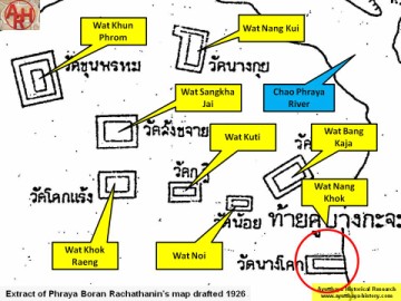
| (Detail of Phraya Boran Rachathanin's map - Anno 1926) |
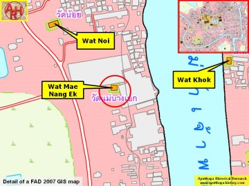
| (Detail of a 2007 Fine Arts Department GIS map - Courtesy of the Fine Arts Department - 3th Region) |
