| WAT PA PHAT (วัดป่าพัด) |
| Wat Pa Phat or the Monastery of the Fan Quarter was situated on the city island in the southwestern area of Ayutthaya in Pratu Chai Sub-district. The temple was located at the confluence of Khlong Chakrai Yai and Khlong Tha Phra aka Khlong Klaep. The monastery stood on the west bank of Khlong Chakrai Yai and on the south bank of Khlong Tha Phra. Wat Pi Rai (no traces anymore) stood in the north opposite of Khlong Klaep, while Wat Jao Phram (restored ruin) was in the south. The ancient site was cleared in the early 1970's during construction works of an expansion project of the (former) Ayutthaya Agriculture School (Withayalai Kasetrakam). There are no traces of foundations or brick work anymore at ground level and the temple is classified as disappeared. [1] Historical data about the monastery and its construction is unknown. The monastery got its name from the locality it stood and where small and large fans were made from sugar palm leaves. In the area was also a fresh market called Fan Village Market. [2] The site is mentioned on Phraya Boran Rachathanin's map drafted in 1926. A mid-19th century map denominates the location of Wat Pa Phat as Wat Yi Rai. The oldest map positions Wat Yi Rai just opposite of Wat Salak, on the south bank of Khlong Klaep. Seemingly through the years there has been a mix-up of the names of different sites in this area. Wat Pa Phat must have been located in Approx. geographical coordinates: 14° 20' 47.65" N, 100° 33' 21.19" E. References: [1] Bangkok Post - 09 Dec 1972 - Work suspended on Ayutthaya sites. The article states that “machinery engaged on the Ayutthaya Agriculture School extensions ploughed up the ruins of at least five temples in the disputed area”. The work at the school was stopped after students had sent a petition to the NEC. The Director General of the Fine Arts Department at that time stated he was certain the damage had already been done. [2] Markets and Production in the City of Ayutthaya before 1767: Translation and Analysis of Part of the Description of Ayutthaya - Chris Baker - Journal of the Siam Society, Vol. 99, 2011 - page 66. |

| | | | | | | | |
| Text & maps by Tricky Vandenberg - October 2009 Updated April 2011, March 2013, January 2015 |
| | | | | | | |
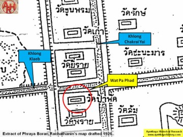
| (Detail of Phraya Boran Rachathanin's map - Anno 1926) |

| (Detail of a 19th century map - map is orientated S-N) |
| (Detail of a 1993 Fine Arts Department map - Courtesy Khun Supot Prommanot, Director of the 3th Regional Office of Fine Arts) |

