| WAT CHANA MAN (วัดชะนะมาร) |
| Wat Chana Man or the Monastery of Victory over Mara was situated on Ayutthaya's city island in the Historical Park in Pratu Chai Sub-district. On Phraya Boran Rachathanin's map drafted in 1926, the temple was located on the crossing of Khlong Chakrai Yai (called Khlong Tho in its northern stretch) - and Khlong Pa Mo, an extension of Khlong Klaep aka Khlong Tha Phra. On its north stood Wat Rak (no traces anymore); opposite Khlong Chakrai Yai was Wat Yi Rai (aka (Wat Pi Rai - no traces anymore) (1) and on its east was Wat Nong (aka Wat Thong - no traces anymore). I think this temple is mentioned under the name Wat Som Yai on a mid-19th century map. Wat Som Yai stood south of Wat Rak and northeast of Wat Pa Phrai. To the south was Wat Som Noi. The monastery stood along the east bank of Khlong Chakrai Yai and at the confluence with Khlong Klaep. On the opposite site of Khlong Chakrai Yai and on the southern bank of Khlong Klaep stood Wat Yi Rai, while on the northern bank was Wat Salak. The mid-19th century map indicates the presence of a chedi. Taking as reference point Khlong Klaep on both maps, the location of Wat Som Yai is denominated on Phraya Boran Rachathanin's map as Wat Chana Man. There are no traces of foundations or brick work at ground level and the temple is classified as disappeared. Historical data about the monastery and its construction is unknown. The site must have been approximately situated in geographical coordinates: 14° 20' 52.69" N, 100° 33' 25.69" E. Footnotes: (1) It should be noted that Phraya Boran Rachathanin positioned Wat Yi Rai on the northern bank of Khlong Klaep. |

| | | | | | | | |
| | | | | | | |

| Text & maps by Tricky Vandenberg - April 2009 Updated March 2014 |
| (Detail of Phraya Boran Rachathanin's map - Anno 1926) |
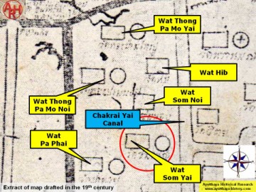
| (Detail of a 19th century map - Courtesy Sam Chao Phraya Museum) |

| (Detail of a 1993 Fine Arts Department map - Courtesy Khun Supot Prommanot, Director of the 3th Regional Office of Fine Arts) |
