
| | | | | | | |
| KHLONG THO |
| Text & maps by Tricky Vandenberg - April 2013 |
| | | | | | |
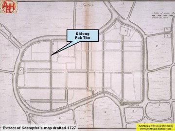
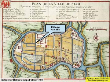
| Khlong Tho (also called Khlong Pak Tho) is a still existent canal situated on Ayutthaya's city island, west of the Grand Palace. The canal was a shortcut in the oxbow of the old Lopburi River. It has today its origin at Khlong Mueang opposite Wat Choeng Tha and its mouth at the Chao Phraya River in front of Wat Phutthai Sawan. In its southern stretch, the canal is called Khlong Chakrai Yai, identical to the defunct Pratu Khao Pluak Canal, which extension is called Pratu Jin Canal. [1] It is one of the three large canals running north to south of which two still are in existence. Five bridges crossed Khlong Tho - Chakrai Yai. [2] The first bridge called Saphan Thong or Gold Bridge crossed the Tho Canal right below its confluence with the Lopburi River and led into the palace grounds near the Khuha Chong Lom Gate (1). This bridge stood likely in the area where today U-Thong Rd crosses Khlong Tho just below the Khlong Tho Water Regulator. A second brick bridge called the Saphan Sai So or Chain Bridge crossed the canal in front of the Maha Phokharat Gate of the Grand Palace. A third bridge called Saphan Lam Hoei or Wry Waterway Bridge connected the road coming from the Rear Palace called Thanon Lao or Lao Street with Thanon Talaeng Kaeng or the "Street of the Gallows". A fourth bridge called Saphan Nang Hong or Lady Swan Bridge connected Wat Khwit Road (2) with Wat Kuti Salak. The fifth and last bridge over Khlong Tho was the wooden Khun Lok Bridge north of the Chakrai Yai Water Gate. Sujit Wongthet indicates it just opposite Wat Jao Phram on one of his maps. Both entry and mouth of the canal had water gates (3) respectively the Pratu Pak Khlong Tho and the Pratu Chakrai Yai water gates. These water gates have been replaced by modern water regulators since the severe flooding of Ayutthaya in 1995. The regulators were of no avail during the flood of 2011. The ponds of the Grand Palace were fed by the waters of the Tho Canal. For this purpose there were two palace water gates. The Udom Khongkharat Gate referring to Mae Khongkha, the Goddess of Water, filled the moat around the Banyong Ratanat Maha Prasat. Another water gate called the Cholachat Thawara Sakhon Gate regulated the outflow from the Crystal Pond inside the royal palace. (4) On the east bank of the canal along the western wall of the palace there were two fortresses being Pom Thai Sanam (also called Pak Tho Fortress at the entry of the canal) and Pom Suan Angun (at the end of the Crystal Pond at the Grape Garden corner) being part of the palace defenses. There was no fortress at the mouth of Khlong Chakrai Yai opposite Wat Phutthai Sawan (5). From Khlong Tho there were a number of smaller canals departing. On the east side the most important side canals were Khlong Nakhon Ban and Khlong Pa Mo; on the west side Khlong Fang, Khlong Chang Maha Chai and Khlong Klaep. It is not known were exactly Khlong Tho ends and Khlong Chakrai Yai begins and its denomination is likely depending of who is living in what part. For the ease I will end Khlong Tho at Saphan Lam Hoei. Most of the points of interest along the canal with exception of the Grand Palace were along the Chakrai Yai section, so I will cite them there. Footnotes: (1) This gate could not be determined on the Grand Palace area. (2) The road must have been called after a temple in the vicinity. Until today I could not find any trace of a Wat Khwit on the old maps of Ayutthaya. (3) Two of the eleven water gates around Ayutthaya city island. (4) There is discussion whether this gate regulated the outflow of the moat around the Banyong Ratanat Maha Prasat or the outflow of the Crystal Pond in the Grape Garden. (5) Here also is discussion whether the Suan Angun Fortress stood in the NW or the SW corner of the Grape Garden. References: [1] Tamnan Krung Kao. [2] Geographical description of Ayutthaya: Documents from the palace - Dr Winai Pongsripian - Bangkok (2007) - page 35-6. |

| (Detail of Phraya Boran Rachathanin's map - Anno 1926) |
| (Bellin's 1750 map) |
| (Khlong Tho on Kaempfer's map) |