| WAT CHO (วัดเฉาะ) |

| | | | | | | | |


| Text & photographs by Tricky Vandenberg - July 2009 Review April 2013 |
| | | | | | | |
| (View from the east) |
| (View from the west) |
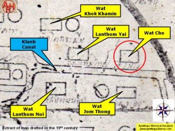
| Wat Cho (1) is located on the city island in the southwest area in Pratu Chai Sub-district, northwest of the Somdet Phra Sri Nakharin Park. The site is part of the Ayutthaya Historical Park. The ruins of the temple lay east of U-Thong Rd, more or less opposite Wat Chai Watthanaram. The ruins can be easily reached. Wat Cho stood on the south bank and close to the mouth of Khlong Tha Phra (also called Khlong Klaep). At the mouth was a water gate called Pratu Khlong Klaep (Pratu Khlong Tha Phra) and a boat landing in connection with Wat Lot Chong, called Phra Racha Wang Lang Landing. The foundations of the monastery are still visible, being likely from a sermon hall. No traces of boundary stones were found. The entry of the hall is to the east. The floor of the main chedi is situated on the west side of the hall. The hall was surrounded by an inner wall, while the whole complex was protected by an outer wall. The history and period of construction of Wat Cho is not known. Wat Cho is indicated on a mid-19th century map in an identical position as on Phraya Boran Rachathanin's (PBR) map drafted in 1926, east of Wat Phra Ngam. Wat Maha Saman was situated south. On the oldest map Wat Chang was located opposite, on the north bank of the canal; but PBR indicates a cluster of four temples in that location. The site is located in geographical coordinates: 14° 20' 45.64" N, 100° 32' 44.10" E. Footnotes: Cho (เฉาะ.) = to chop, break or slit open or (เฉาะ ๆ ) = comfortable. |

| (Detail of Phraya Boran Rachathanin's map - Anno 1926) |
| (Detail of a 19th century map - Courtesy Sam Chao Phraya Museum) |


| (Detail of a 2007 Fine Arts Department GIS map - Courtesy of the Fine Arts Department - 3th Region) |