| WAT KLANG KHLONG TAKHIAN (วัดกลางคลองตะเคียน) |
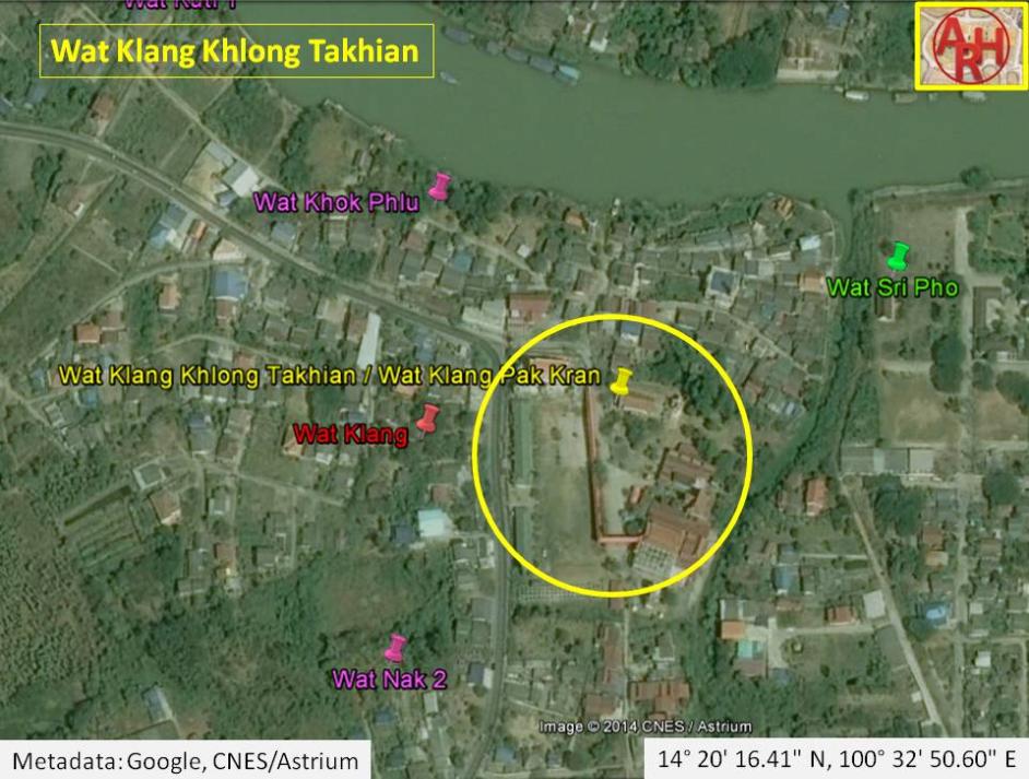
| Wat Klang Khlong Takhian or the Monastery in the Middle of Takhian Canal is an active temple located off the city island in the southern area of Ayutthaya in Pak Kran Sub-district. The monastery also know as Wat Klang Pak Kran, is situated at the confluence of the Chao Phraya River and Khlong Takhian (1), on the west bank of the latter. The St Joseph Church and the ancient Cochin Chinese Settlement lies just opposite the other bank of the canal. The old Wat Klang is situated to its west, opposite the road. Wat Nak lies just south of Wat Klang. Opposite the Chao Phraya River is Wat Wang Chai. In situ we find the classic monastic structures. The monastery is quite large, but dates from the post Ayutthaya period. The ordination hall was built in the Late Ayutthaya style (1629-1767 AD). The hall has two elevated porches with each two entries and the two-tiered roof is supported by four columns. The longest walls of ubosot have five windows each. The hall is surrounded by an inner wall or crystal wall (Th: Kamphaeng Kaeo) demarcating the sacred area. Historical data about the monastery and its construction are unknown. The site is not indicated on Phraya Boran Rachathanin's map drafted in 1926. This could be an indication that this monastery was constructed after 1926 as a substitute for the old Wat Klang. Near Wat Klang and Wat Nak was one of the five former ferry crossings across the Chao Phraya River, linking the monasteries with Tha Wang Chai (Wang Chai landing). (2) [1] Wat Klang Khlong Takhian is located in geographical coordinates: 14° 20' 16.1" N, 100° 32' 51.3" E (14.337808, 100.547577). Footnotes: (1) Also called Khu Lakhon Chai or "Le Canal du Grand Cochon" (Great Cochon River). A floating market (Khlong Khu Lakhon Chai market) was held at the mouth of this canal. [2] (2) In Ayutthayan times there were twenty-two ferry routes between the main land and the city island. The southern area had six crossings: Hua Sarapha to Wat Phanan Choeng, Tha Hoi to Wat Pa Jak, Tha Phra Rachawangsan to Wat Khun Phrom, Tha Dan Chi to Wat Surintharam, Tha Chakrai Noi to Wat Tha Rap and Tha Wang Chai to Wat Nak. [1] See "The Boat & Ferry Landings of Ayutthaya". References: [1] Athibai Phaenthi Phra Nakhon Sri Ayutthaya kap khamwinitjai khong Phraya Boran Racha Thanin - Explanation of the map of the Capital of Ayutthaya with a ruling of Phraya Boran Rachathanin - Revised 2nd edition and Geography of the Ayutthaya Kingdom - Ton Chabab print office - Nonthaburi (2007) - page 91. [2] Discovering Ayutthaya - Charnvit Kasetsiri & Michael Wright (2007) - page 272. |

| | | | | | | | |

| | | | | | | |
| Text, map & photographs by Tricky Vandenberg - February 2010 Updated February 2019 |
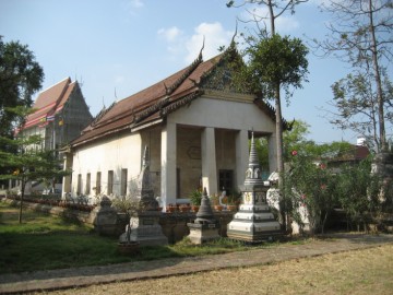
| (Ubosot seen from the east) |
| (Ubosot - side view) |


| (Detail of a 2007 Fine Arts Department GIS map - Courtesy of the Fine Arts Department - 3th Region) |