| WAT KHWANG (วัดขวาง) |
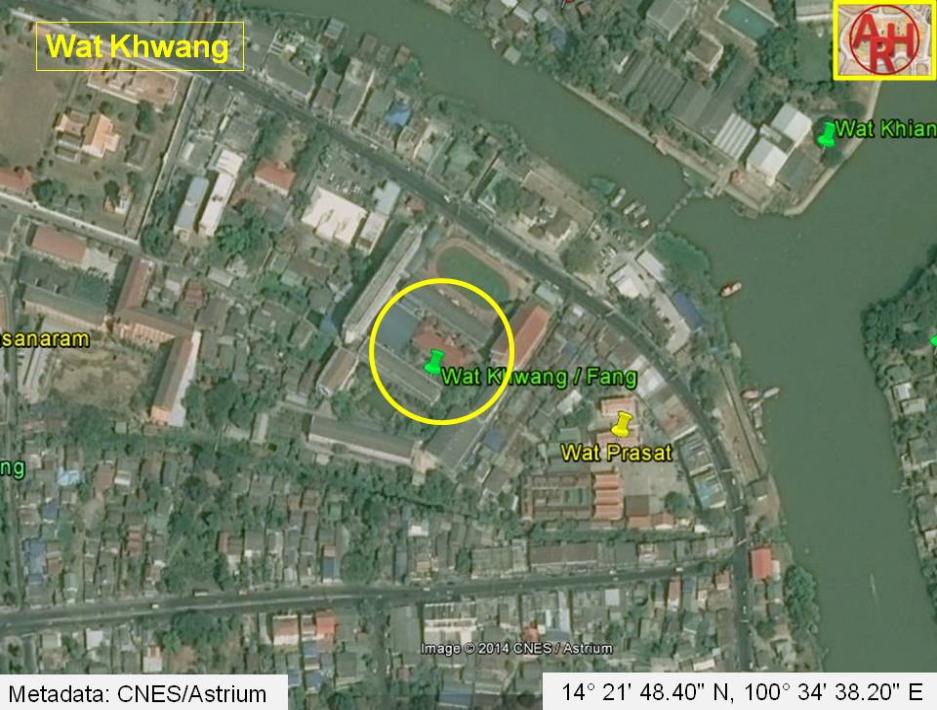
| Wat Khwang was located on the city island in the northeastern area at Ho Ratanachai sub-district. It was situated north of Wat Prasat and Khlong Ho Ratanachai. The monastery is often referred to as Wat Fang in old documents. Hengpujaroen wrote that according to some old documents, the walls around the Chan Kasem Palace or Front Palace had a length of 50 Sen (1) or approximately 2000 m. The palace occupied thus an area roughly going from the Unmilled Rice Fort (Pom Khao Phluak) and Wat Tha Sai towards the Maha Chai Fort; going down to the Ho Ratanachai Gate and running back along the Ho Ratanachai canal towards the Unmilled Rice Gate. The palace area should have included at least eight monasteries, which one of them was Wat Khwang. The issue of a such large palace ground as mentioned here, was although heavily discussed by scholars and rejected. [1] A fortress being part of the defense wall erected around 1580, stood east of the temple along the Front City Canal and was called Pom Wat Fang (Pom Wat Khwang). Nothing remains of the former monastery, which location should have been where the present "Chomsurang Upatham School" is situated. Its historical background and period of construction are unknown. The main Buddha statue of this temple was moved to Wat Prasat. The temple is mentioned in some of the Royal Chronicles of Ayutthaya in the period just before the first fall of the city in 1569, when the King of Hongsawadi ordered the construction of a causeway from probably the vicinity of Wat Saphan Kluea towards Wat Fang. "When the inventory of all the troop supplies ordered by the King completed, the King of Hongsawadi had preparations made for attacking the Capital and order causeways laid extending in towards the front ramparts of the city from three points; from the positions of the Uparat the first was to be laid extending in to Fang Monastery and a second to Ian Village, and from the positions of the King of Ava a third was to be laid extending in to the corner of Kaeo Island." [2] Close to Wat Fang monastery and to the mouth of Khlong Ho Ratanachai, was one of the former five eastern ferries across the Front city canal - linking the city with Wat Nang Chi on the opposite side. (2) [3] In the Late Ayutthaya period (1629 - 1767 AD) there were shops and workshops making and selling heads and skeletons of spinning wheels, and chests for cotton around Wat Fang and there was also a fresh market called the Wat Fang Market. [4] The site is indicated on a mid-19th century map denominated Wat Fang (วัดฟัง) and on Phraya Boran Rachathanin's map drafted in 1926 map, here named Wat Khwang (วัดขวาง). Wat Kwang was situated in Geo Coord: 14° 21' 48.40" N, 100° 34' 38.20" E. Footnotes: (1) Sen is a traditional Thai unit of length equal to 40 m. (2) In Ayutthayan times there were twenty-two ferry routes. In the eastern area, the four other crossings were: Tha Chang Wang Na to Tha Wilanda, north of Wat Khwang Fortress to Wat Taphan Kluea, South of Wat Pa Thon to Wat Phichai and north of Rachakrue Fortress to Wat Ko Kaeo. [3] See "The Boat & Ferry Landings of Ayutthaya". References: [1] The study of Chantharakasem Palace for developing the Management Plan - Nantana Hengpujaroen (2003). [2] The Royal Chronicles of Ayutthaya - Richard D. Cushman (2006) - page 62 / Source: Thonburi fragment (1779) Khurusapha (1963). [3] Athibai Phaenthi Phra Nakhon Sri Ayutthaya kap khamwinitjai khong Phraya Boran Racha Thanin - Explanation of the map of the Capital of Ayutthaya with a ruling of Phraya Boran Rachathanin - Revised 2nd edition and Geography of the Ayutthaya Kingdom - Ton Chabab print office - Nonthaburi (2007) - page 91. [4] Markets and Production in the City of Ayutthaya before 1767: Translation and Analysis of Part of the Description of Ayutthaya - Chris Baker - Journal of the Siam Society, Vol. 99, 2011 - page 64. |

| | | | | | | | |

| Text, maps & photographs by Tricky Vandenberg - August 2009 Updated May 2011, March 2013, December 2014 |
| | | | | | | |
| (View of the former location of Wat Khwang) |


| (Detail of a 19th century map - map is orientated S-N) |
| (Detail of Phraya Boran Rachathanin's map - Anno 1926) |

| (Detail of a 2007 Fine Arts Department GIS map - Courtesy of the Fine Arts Department - 3th Region) |