| WAT PHRA NGAM 1 (วัดพระงาม) |

| | | | | | | | |
| Wat Phra Ngam was located on Ayutthaya's city island in the south in Pratu Chai sub-district. The monastery was located on the bank of Khlong Pa Mo, an extension of Khlong Klaep. It was situated in an area called Thung Khaek below Khok Khaek. Wat Jingjok was in the north, Wat Singharam in the south and Wat Am Mae in the east. There are no traces anymore visible of the monastery above ground level. The exact location is presently difficult to determine as maps give slightly different locations for this monastery. Historical data about the monastery and its construction are unknown. Beside Wat Phra Ngam on White-clay Quarter Road there were shops selling white-clay powder, made from old marble; and white, yellow, and black white-clay powder. (1) The site is indicated on Phraya Boran Rachathanin's map drafted in 1926. Wat Phra Ngam is indicated on a 2007 Fine Arts Department (FAD) map. In fact it shows the position of the Lion Bridge. I presume no traces of the defunct monastery were found by the FAD. Wat Phra Ngam was located in Geo. Coord.: 14° 20' 54.19" N, 100° 33' 42.46" E. Footnotes: (1) Chris Baker notes "dinso": a powder made from white clay, used in writing and also applied to the body like talcum for cooling and whitening. References: [1] Markets and Production in the City of Ayutthaya before 1767: Translation and Analysis of Part of the Description of Ayutthaya - Chris Baker - Journal of the Siam Society, Vol. 99, 2011 - page 62. |
| | | | | | | |
| Text & maps by Tricky Vandenberg - March 2010 Updated April 2013, March 2015 |
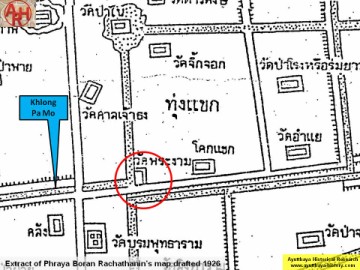
| (Detail of Phraya Boran Rachathanin's map - Anno 1926) \ |

| (Detail of a 2007 Fine Arts Department GIS map - Courtesy of the Fine Arts Department - 3th Region) |

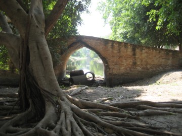
| (Saphan Sing or the Lion Bridge near the defunct Phra Ngam Monastery) |